
 | ||
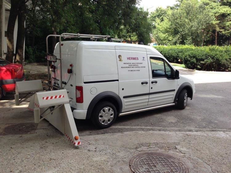
The Hermes Road Measurement System is the result of the EU-funded project Innovative, Highly Efficient Road Surface Measurement and Control System that was undertaken between August 2012 and July 2014. The project was funded through the European Union's Seventh Framework Capacities Programme that aimed at supporting research for the benefit of small-to-medium enterprises (SMEs). This is realised by cooperation between a group of SMEs from several European countries, working in collaboration with a number of research and technological development (RTD) institutes, collectively constituting the project's consortium.
Contents
- Objectives
- Measured parameters
- Accuracy
- Standards compliance
- System description
- Dissemination and exploitation
- SME participants
- Research and technological development partners
- References
The Hermes system enables both the longitudinal and transversal profiles of a road to be simultaneously measured from a specially equipped vehicle travelling at normal road speeds. The developed approach has the advantage of eliminating the need for an inertial reference level, whilst improving accuracy of measurements by addressing errors otherwise resulting from the dynamics of a moving vehicle. An additional feature of this system is integration of the road profile measurements with their precise geographical location.
Objectives
The project's objectives include the following:
Measured parameters
These include transversal road profile, macro-texture measurements, longitudinal profile, rut depth, rut width, cross fall, curve radius, cracks, International Roughness Index (IRI), mean profile depth, vehicle speed, position relative to the start point, GNSS position, together with pavement imaging and time-stamping of measurements.
Accuracy
Standards compliance
The work has been set to meet a number of requirements that were formed based on the results of questionnaires collected from interested parties. Hence, the following standards are met:
System description
The Hermes system comprises a mobile unit, i.e., a special measurement vehicle having laser projection and camera imaging equipment. Acquired data is logged by a computer using a relational database. Data is subsequently post-processed using Structured Query Language-based queries, together with sophisticated custom-developed data analysis software.
The measurement principle is based on projecting a laser line on the road surface and recording its image using a high resolution camera of high frame rate. The deviation of the laser line is measured, which corresponds to undulations of the road surface.
A novel automated pothole detection algorithm has also been developed to automatically characterise the quality of the road surface and detect potentially hazardous defects. A specially-developed GNSS controller provides high accuracy localisation of acquired measurement data.
Dissemination and exploitation
The developed system addresses the needs of a broad spectrum of potential end-users, including road maintainers, road constructors, air-field maintainers and national technical control centres responsible for road maintenance. The novel Hermes technology has been disseminated through a range of different activities including the following: