
OS grid reference SN044276 Sovereign state United Kingdom Police Dyfed-Powys Community New Moat | Country Wales Postcode district SA63 | |
 | ||
Henry’s Moat is a hamlet and parish in Pembrokeshire, Wales, in the community of New Moat. It is 7 miles (11 km) southeast of Fishguard and 9 miles (14 km) northeast of Haverfordwest. The nearest railway station is Clarbeston Road 5 miles (8 km) to the south. It was in the ancient Hundred of Cemais.
Contents
Map of Henry's Moat, Clarbeston Road, UK
Name
The parish’s Welsh name was Castell Hên-drêv (or Hendre), Anglicised by early English settlers to its present form. It derives from an ancient tumulus surrounded by a moat.
History
In 1833 the population of the parish was 282. It includes the hamlet of Tufton on the nearby B4329 Cardigan to Haverfordwest turnpike.
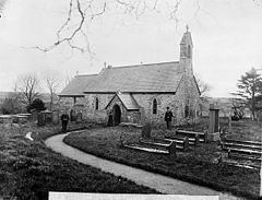
Church
The parish church is dedicated to St Brynach (English: St Bernard).
References
Henry's Moat Wikipedia(Text) CC BY-SA