
Population 463 (2011 census) Location 9 km (6 mi) from CBD | Postcode(s) 2111 Postal code 2111 | |
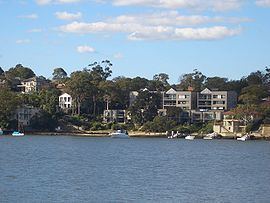 | ||
Henley is a suburb on the lower North Shore of Sydney, in the state of New South Wales, Australia. Henley is located 9 kilometres west of the Sydney central business district, in the local government area of the Municipality of Hunter's Hill. Henley sits on the northern side of the Parramatta River.
Contents
Map of Henley NSW 2111, Australia
History
The suburb's name is derived from its namesake Henley, by the banks of the Thames in Oxfordshire, England. Parramatta River had been known as the 'Thames of the Antipodes' and other nearby suburbs were also named after Thames localities of Greenwich, Woolwich and Putney.
European settlement
Henley was originally known as Blandville, after Dr William Bland (1789-1868) who was transported for killing a fellow naval officer in a duel. Bland arrived in 1814 but was pardoned in 1815 and began a private practice. Bland resided in the city but owned the land here that he subdivided in 1866.