
 | ||
Friends of hempstead plains introduction
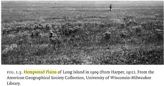
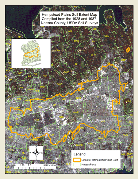
The Hempstead Plains is a region of central Long Island in New York state in what is now Nassau County. It was once an open expanse of native grassland estimated to once extend to about 60,000 acres (240 km2). It was separated from the North Shore of Long Island by the Harbor Hill Moraine, later approximately the route of Route 25. The modern Hempstead Turnpike approximately traces the separation of the plain from the South Shore of Long Island. The east-west extent was from somewhat west of the modern Queens, New York City border to slightly beyond the Suffolk County border.
Contents
- Friends of hempstead plains introduction
- Hempstead plains 1911
- Horse racing
- Aviation
- Current trends
- References

The Town of Hempstead, now America's most populous civil township, was first settled by Europeans around 1644. Although the settlers were from the English colony of Connecticut, a patent was issued by Dutch New Amsterdam after the settlers had purchased land from the local Native Americans. The town may have been named for either Hemel Hempstead, England, or the city of Heemstede in North Holland.
In early US history, the Hempstead Plains region was cited as one of the few natural prairies east of the Allegheny Mountains. Long Island historians George Dade and Frank Strand wrote that it was created by an outwash of glacial sediment more than ten thousand years ago. The result was vast, flat open land.
Hempstead plains 1911
Horse racing
Horse racing in the United States and on the North American continent dates back to the establishment of the Newmarket course on the Salisbury Plains section of the Hempstead Plains of Long Island in 1665. This first racing meet in North America was supervised by New York's colonial governor, Richard Nicolls. The area is now occupied by the present Nassau County region of Greater Westbury and Garden City.
The year 1905 saw the opening of Belmont Park on part of the western edge of the Hempstead Plains. Its mile and a half main track is the largest dirt Thoroughbred race course in the world, and it has the sport's largest grandstand.
Even for non-jockeys, sports remains a key part of the Hempstead Plains. The South Westbury section of the plains is (appropriately) known as Salisbury, and Nassau County's largest park (more than 800 acres (3 km²)) was established in the region as Salisbury Park in the 1940s, on the site of the former Salisbury Golf Links. The county facility has been known as Eisenhower Park since 1971.
Even during the later era of air flight activity on the Hempstead Plains, part of the east section of privately owned Roosevelt Field became Roosevelt Raceway, first a popular auto-racing site and then the pioneering standardbred track in horse racing, from 1940 to its closing in 1988.
Aviation
Another pioneering industry on the Hempstead Plains was aviation. In July 1909, aviator and manufacturer Glenn Curtiss relocated his base of operation from his native upstate New York to Mineola. Curtiss, at the controls of his biplane the Golden Flyer, circled the plains' Washington Avenue field for more than 52 minutes, demonstrating the aircraft's capabilities and earning the Scientific American prize for a flight of more than 25 kilometres (16 mi).
Some 15 years later, the Hempstead Plains had earned the appellation "Cradle of Aviation". The Hempstead Plains Aerodrome was renamed to in 1917 to Hazelhurst Field, and again in 1918 to Roosevelt Field on the eastern half, and Curtiss Field to the west. These facilities and Mitchel Field provided the eastern US's hub of private, and even military, air activity.
The most famous flight from the Hempstead Plains was Charles Lindbergh's 1927 journey to France. On May 20-May 21, Lindbergh, aboard the single-engine monoplane Spirit of St. Louis, was the first pilot to fly from the U.S. solo and nonstop across the Atlantic Ocean, flying from Roosevelt Field to Le Bourget, Paris, in 33½ hours. (His grandson Erik Lindbergh repeated this trip in 2002, 75 years later, in 17 hours 17 minutes.)
Current trends
With the mid-century period came suburbanization and commercial development of the Plains region. The west section of Roosevelt Field (once known as Curtiss Field before its 1929 merger with Roosevelt) ceased operations in 1951 and has been occupied since 1956 by the Roosevelt Field Mall, one of the world's largest indoor shopping centers.
To the east, the former Roosevelt Raceway section is occupied by a multiplex cinema, Target and luxury condominiums. The section north of the raceway, development on which dates back to the 1960s, is occupied by The Source Mall (anchored by the flagship of the Fortunoff department stores) and the Costco center.
Mitchel Field, which includes the Hempstead Plains site formerly known as Camp Mills, housed an Air Force base until 1961 and is currently used for multiple sites, including the Cradle of Aviation Museum, Nassau Community College, Nassau Veterans Memorial Coliseum and some of the housing and recreational facilities for Hofstra University.
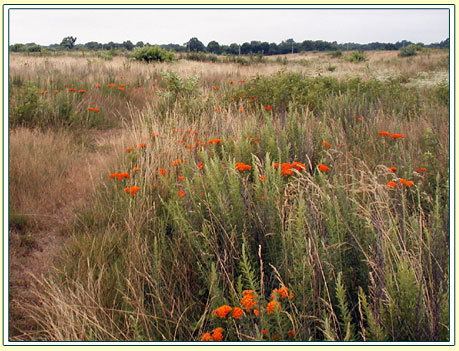
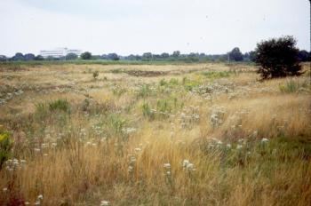
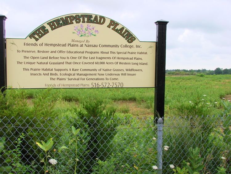
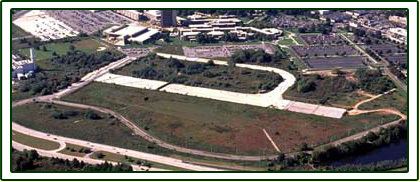
The last remaining few acres of untouched Hempstead Plains ground exist near Nassau Community College, immediately adjacent to the Power Plant as well as directly behind the Marriott Hotel. Additionally, in back of The Wheatley School, the high school of the East Williston School District, in Old Westbury. The area is known as the Wheatley Woods for the trees that hide the acres of plains. There are also plains in Eisenhower Park. The plains stretched east to the Suffolk County border. Several acres also remain in Plainview. The existing area was slated to be an extension of the Bethpage State Parkway which was not built, and the land was never developed.