
Country United States FIPS code 27-28250 Elevation 443 m Population 639 (2000) | Time zone Central (CST) (UTC-6) GNIS feature ID 0664440 Local time Sunday 1:30 AM | |
 | ||
Weather 1°C, Wind SE at 18 km/h, 82% Humidity Area 185.2 km² (150.2 km² Land / 34.96 km² Water) | ||
Height of Land Township is a township in Becker County, Minnesota, United States. The population was 639 as of the 2000 census.
Contents
- Map of Height of Land Township MN USA
- History
- Geography
- Major highways
- Lakes
- Adjacent townships
- Cemeteries
- Demographics
- References
Map of Height of Land Township, MN, USA
History
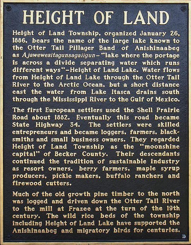
Height of Land Township was organized in 1886. The township is the English translation of an Ojibwe language name for the Height of Land Lake.
Geography
According to the United States Census Bureau, the township has a total area of 71.5 square miles (185 km2), of which 58.0 square miles (150 km2) is land and 13.5 square miles (35 km2) (18.84%) is water.
Major highways
Lakes
Adjacent townships
Cemeteries
The township contains these five cemeteries: Church of the Wildwood, Mennonite, Mount Olive, Saint John's Lutheran and Senjen.
Demographics
As of the census of 2000, there were 639 people, 244 households, and 186 families residing in the township. The population density was 11.0 people per square mile (4.3/km²). There were 385 housing units at an average density of 6.6/sq mi (2.6/km²). The racial makeup of the township was 96.56% White, 1.56% Native American, 0.16% from other races, and 1.72% from two or more races. Hispanic or Latino of any race were 0.31% of the population.
There were 244 households out of which 28.3% had children under the age of 18 living with them, 70.5% were married couples living together, 4.5% had a female householder with no husband present, and 23.4% were non-families. 18.0% of all households were made up of individuals and 6.6% had someone living alone who was 65 years of age or older. The average household size was 2.62 and the average family size was 2.98.
In the township the population was spread out with 24.3% under the age of 18, 7.8% from 18 to 24, 25.8% from 25 to 44, 32.2% from 45 to 64, and 9.9% who were 65 years of age or older. The median age was 40 years. For every 100 females there were 111.6 males. For every 100 females age 18 and over, there were 107.7 males.
The median income for a household in the township was $36,154, and the median income for a family was $39,500. Males had a median income of $26,071 versus $20,952 for females. The per capita income for the township was $16,973. About 6.9% of families and 8.1% of the population were below the poverty line, including 1.3% of those under age 18 and 10.7% of those age 65 or over.