
Country Lebanon District Hasbaya District Region Hasbaya | Governorate Nabatieh Governorate Population 1,800 (1970) | |
 | ||
Merhaba hebbariyeh
Hebbariye, Hebbariyeh, Hebbariya or Hebariya (Arabic: هبّارية) is a village and municipality situated in the Hasbaya District of the Nabatieh Governorate in Lebanon. It is located on the southwestern slopes of Mount Hermon near the Syrian border, northeast of Rachaya Al Foukhar and is positioned amongst orchards of apricot trees.
Contents
Map of Habbariyeh, Lebanon
The village sits c. 750 metres (2,460 ft) above sea level and the small population is predominantly Sunni Muslim.
Hebbariyeh dar el3ain dai3a video
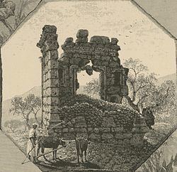
Roman temple
There is a Roman temple near to the village, opposite the Wadi Shib'a which is the most southern of the Temples of Mount Hermon, a group defined by George Taylor as being south of the main road to Damascus on the west of Mount Hermon, including the Wadi al-Taym area. It has been classified as an Antae temple with an eastern portal that faces Mount Hermon, aligned "as if to catch the first beams of the morning sun rising over Hermon." The temple has a large basement chamber underneath the cella floors that is thought to have been used for burial. The room is only accessible from the outside of the building. The temple was surveyed in the summer of 1852 by Edward Robinson who noted several large blocks with one measuring 2.75 feet (0.84 m) by 15 feet (4.6 m). He measured the dimensions of the temple to be 58 feet (18 m) long by 31 feet (9.4 m) wide with 6 feet (1.8 m) thick walls around 32 feet (9.8 m) high. The capitals appeared to be of an Ionic style. At the entrance doorway, there are two tiers of niches with some engraved writing beneath the upper set.