
 | ||
The Outer Banks are the barrier islands along the east coast of North Carolina, that are extremely sensitive to environmental hazards, particularly hurricanes. This article is about how people of the Outer Banks prepare for natural disasters.
Contents
Geography
The chain of sand islands begins at the southeast corner of Virginia Beach and run parallel to most of North Carolina's coastline. The long thin strip of land mass separates the Atlantic Ocean from the Currituck, Albermarle, and Pamlico sounds. The sanctuary of these sounds contains large inlets, bays, and a massive lagoon providing estuaries and habitats for hundreds of species which are protected by the Outer Banks. From the folklore of Blackbeard's pirates and the history of over a thousand shipwrecks that have occurred in the Graveyard of the Atlantic to the birth of flight engineered by the Wright Brothers, the history of the islands have conducted much attention towards the Outer Banks. Scenic views and the temperate climate have drawn thousands of people to relocate along the Outer Banks beachfront. Tourist began to travel down from New York to the Outer Banks after the end of the Civil War to hunt waterfowl. Monumental varieties of duck, geese, and other water birds manifested a new hunting industry for the Outer Banks constructing hotels, cafes, and stores. Eventually roads and bridges were built due to the rapid growth and popularity of the Outer Banks. Each year the Outer Banks receive an extensive amount of visitors that have been attracted by restaurants, shopping, historic monuments, and lively entertainment.The desired vacation destination of the Outer Banks provides economic and employment development for residents. The serenity provided by the exceptional real estate supplemented by the Outer Banks can be quickly turned upside down and into a nightmare if encountered by a hurricane. Hurricanes are an extreme concern for the stability and existence of the Outer Banks. The Outer Banks are highly vulnerable when threatened by a hurricane. When a hurricane is forecasted to strike the Outer Banks, a hazard mitigation plan must be developed. The goal of a hazard mitigation plan is to identify the policies and tools that are needed to be implemented in order to reduce or even eliminate the risk of life and property loss from any event that may occur in the Outer Banks.
Geography
Offshore deposits of sand and other sediments that parallel the coast line eventually collected over thousands of years by rising waters, waves, currents, and wind which formed the long, narrow barrier islands. The islands of the Outer Banks travel three hundred and twenty five miles along the coast line of North Carolina. The formation of the Outer Banks protects North Carolina's coast line from severe storm damage and harbors the many different habitats surrounded by the islands, providing refuge for wildlife. Several islands are separated from each other by tidal inlets which provide a regular exchange between the water of the ocean to bays and estuaries. The barrier islands and sandbars that configure the Outer Banks are highly fragile and are constantly changing their coastal landscape. Some of the islands that make up the Outer Banks may only be a half mile wide and over time may recede back into the ocean.
Barrier island zones are what structure the islands of the Outer Banks from the ocean side to the sound. The beach faces the ocean and consists mainly of sand deposits brought by wave action. Dunes are formed behind the beach consisting of compacted sand and sediments pile like a hill deposited by the wind. The elevations of dunes are called the 'First Line of Defense' for beach systems. Front dune ridges may be followed by a secondary line of dunes more inland. Plants that grow naturally on dunes stabilize the dunes by their roots preventing potential damage caused by water and wind. Behind the dunes are areas called barrier flats. Barrier flats, also known as over wash or mud flats that are developed by sand sediments forced through dune systems by strong winds caused by storms. Last, salt marshes fall behind Barrier flats that tend to be low-lying areas that border the sound side of the island. Tides flood salt marshes regularly ensuring ecological productive areas. Salt marshes provide unique habitats and purify tarnished waters.
Along the beaches of the Outer Banks plants and beach grasses like Opuntia Humifuia, Cabbage Palmentto, and Sabal Minor are noticed. Pindo and Windmill palms are not indigenous to the area, but are located in many areas mainland. Towards the sound side sea grasses, Yucca Aloifolia and Wax Myrtles nestle. The Maritime Forest also known as the Nags Head Forest can be located within the perimeters of Nags Head. A Maritime Forest is an area of forest affected by sea spray. This forest is located on the mainland side of the island. Oak, ferns, pine, magnolias, cedars, willows, goldenrods, and cattails thrive among the forest. Ancient dune swales provide areas to capture precipitation providing fresh water.
Demographics
North Carolina has 20 Coastal Counties that are part of the Coastal Area Management Act. The Barrier Islands of North Carolina consist of only three of CAMA’s coastal counties for North Carolina; these three counties are Hyde County, Dare County and Currituck County.
The mitigation and recovery plans for these counties lie heavily on their economic and social demographics. These demographic statistics allow these counties and the Barrier Islands as a unit to gain a clearer understanding of the necessary mitigation techniques that need to place in the event of a natural disaster. These counties use a number of different statistics, which can include anything from the amount of households in their counties to the amount of income that these households are earning on a monthly or yearly basis.
Using the 2010 census report, Dare County is the most populated of the three Barrier Island counties, having a population of 33,920 people, 383.42 square miles of land, as well as a population density of 100.26. The second largest county in terms of population is Currituck County which has a population of 23,547 people, while having 261.85 square miles of land, and a population density of 101.39. The third county of the three is Hyde County which has by far the smallest population with 5,810 people but also has the highest land area with 612.70 square miles of land, this correlation can be seen by Hyde County's population density which is only 9.07.
The population percent change from 2000-2010 saw huge increases in two of the counties, Currituck County having a 29.5% change and Dare County having a 13.2% change, but Hyde County actually saw a small decrease with a -0.3% change over these years. This shows that the population in these Barrier Island Counties, except for Hyde County who saw a minimal decrease, are experiencing substantial growth of the past decade.
The median household income from 2006–2010 was $55,376 for Currituck County, while Dare County saw a $44,167 median household income over this time period and Hyde County saw a $38,265 median household income. The median household income somewhat coincides with the percentage of people below the poverty line from 2006–2010, being that if there are more people below the poverty line then the median household income should decrease as well. The percent below the poverty line for Currituck County was only 8.5% while Dare County saw that 16.3% of the people were below the poverty line and Hyde County had 20.4% of people who were below the poverty line. To give you a reference point, the state of North Carolina as a whole has 15.5% of people that are below the poverty line.
The final statistic to include from the U.S. Census is the federal spending that each County received last year. While Hyde County only totaled $70,512 in federal funding Currituck County totaled $230,625 in federal funding and Dare County totaled $725,521. This means that the three counties that the Barrier Islands are a part of totaled over $1 million in federal spending, $1,026,658 to be exact.
Infrastructure
The largest infrastructure when it applies to mileage of the Barrier Islands is North Carolina state highway NC 12 which runs North and South along the shoreline of the Outer Banks and includes 138 miles of roadway. NC 12 is the main road that links together all of the islands of the Outer Banks. Highway NC 12 often is criticized for damaging the natural flow and movement of the Barrier Islands. There are several bridges along highway NC 12 which include the Wright Memorial Bridge, the Virginia Dare Memorial Bridge, the Washington Baum Bridge, and the Bonner Bridge.
Hurricanes
The Outer Banks are susceptible to reoccurring hurricanes that pummel their fragile coastline. Hurricanes are a name for intense tropical cyclones that develop in the Atlantic Basin. A tropical cyclone is a non-frontal low-pressure system that forms over tropical or sub-tropical waters with organized thunderstorm activity and established surface wind circulation. A tropical cyclone begins as a tropical wave that commonly forms of the west coast of Africa. Tropical waves are areas of unsettled weather consisting of vertical air movement. Water vapor is drawn upward from warm surface waters and large amounts of heat energy are released when water vapor rises and condenses. Warm ocean temperatures of eighty degrees or higher to a depth of one hundred and fifty feet are needed to strengthen tropical cyclones. This is why the official hurricane season is from June 1 to November 30 (The summer–autumn peak). To determine the strength of a storm, the process of a developing hurricane is sectioned by four stages. First an organized area of thunderstorms that maintains structure for twenty-four hours or more is recognized as a tropical disturbance. If the develops a surface circulation and sustained maximum wind speeds of 38 mph, the storm advances to a tropical depression. Later, if the storm increases its maximum sustained wind speeds to 39–73 mph, the storm is referred as a tropical storm and at that point is given a name. For the storm to become a hurricane, the organized area of intense thunderstorms will have to developed a well defined area of surface circulation and maximum sustained winds speeds that measure over 74 mph. Hurricanes are classified into five different categories measured by the Saffir-Simpson scale, which categorizes these storms based on their wind speeds, barometric pressure, and storm surge.
Hazards produced by hurricanes
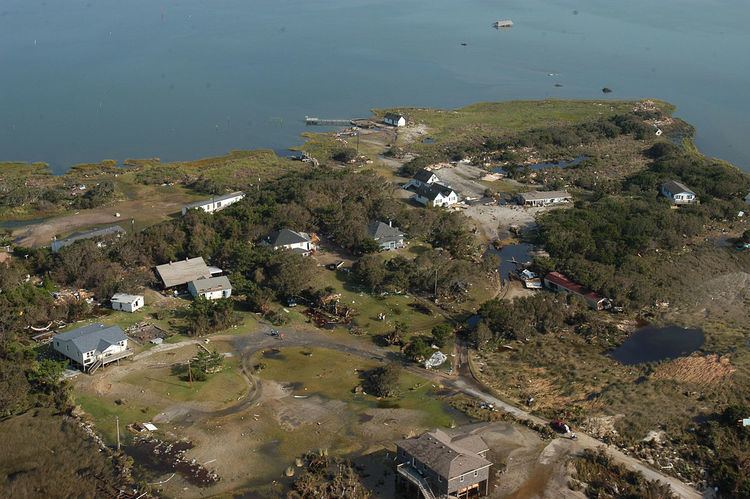
Hurricane-force winds speeds can exceed over 150 mph. Hurricane-force winds can easily destroy buildings not built to hurricane code and mobile homes. During a hurricane anything such as tree limbs to signs can become deadly and destructive flying objects. Intense winds can also uproot trees, damage power poles, and tear away roof tops of houses. Hurricane winds can dismantle communication availability and transportation links, ultimately causing havoc for residents and emergency personal on the Outer Banks. The right side of the eye wall has the highest wind intensity. From the right side of the eye wall is usually where the predominate source for the amount of tornados that are spawned by a hurricane.
Intense rainfalls carried by hurricanes can produce quick accumulation of storm water that is classified as inland flooding. Typical a hurricane will produce an average rainfall between six and twelve inches. The risk of inland flooding for the Outer Banks varies upon several circumstances. Factors such as the speed of the storm greatly affect rainfall amounts. If a hurricane stalls and moves slow along its track the greater amount of time the storm has to dump rain in an area. If areas have received heavy rainfalls prior to a hurricane, soils may already have become saturated and will not be able to discharge standing water. Destructive inland flooding caused by hurricanes can wash away roads and highways which can limit or terminate any vehicular traffic on or off the islands. Current building codes for the Outer Banks require the first floor of a house to be elevated nine to ten feet above sea level. Low lying buildings and vehicles can still be damaged by flood waters.
Along coastal areas, especially for the Outer Banks, storm surge can be a threat to life and property. As a hurricane makes landfall the ocean surface rises by the force of the storms's winds. Storm surges produced by hurricanes can reach heights up to twenty feet. The total height of a storm surge during a hurricane is constructed by the barometric of the storm (the lower the pressure, the higher the surge) and the hurricane's intensity (the higher intensity the higher the surge). The tidal stage also contributes to the storm surge height as well. If an area is at high tide the greater amount of storm surge will the beach receive. When a storm surge pushes through the Outer Banks the sounds and bays fill with water and in time the water recedes from these areas back through the beach outwards to the ocean causing flooding and erosion. Storm surge enhances the frequency of waves and strengthens currents which can severely damage marinas, destroy building structures, wash away coastal highways and erode beaches.
Hazard mitigation and planning
When it comes to mitigation and planning in the Outer Banks, specifically Dare County, they have their own mitigation plan for that specific county. This plan is very detailed and discusses each type of hazard they experience and what resources are available after they experience any given hazard. This mitigation plan was last updated in 2010. This plan focuses on saving lives, saving money, reducing future vulnerability to disasters, a speedy recovery, and facilities post-disaster funding. In this plan they talk about how we cannot prevent these inevitable disasters from happening but as citizens we can develop ways to prevent a significant impact by being prepared by the challenges that may face us.
Goals of the plan
The committee in Dare County that developed this mitigation plan that they have come up with twelve goals to mitigate hazards. These goals were developed for four mitigation activities. These mitigation activities include prevention, property protection, natural resource protection and public information. The preventative section of this plan consists of the first two goals. The first goal for this plan is it to improve storm water drainage and land management in preparation for flooding. Doing this could normally consist of looking at the land layout and trying to find the best way to route the excess water so that there is minimal land disturbance. The second goal is to assist property owners with safe and efficient cleanup and debris removal services after storm events. This goal is a simple one to solve, because the town already has in their mitigation plan that they will have public works out on the roads as soon as it is safe gathering all debris and hauling it away.
The property protection aspect of this mitigation plan consists of the third goal. The third goal for hazard mitigation is to increase the number of properties that meet and exceed BFE. For this goal they first have to identify the most vulnerable structures in the county, then they have to develop a plan of action, then they have to identify where the funding will come from to fix the structures and prioritize the structures accordingly. The last thing in the goal that they will do is implement the plan they created to reduce the potential damage in the future.
The natural resource protection portion of this mitigation plan consists of goals four and five. The fourth goal of the Dare County Mitigation plan is to advocate the use of existing, as of 2010, State and Federal regulatory programs for protecting and preserving coastal wetland area of environment concern. The county receives grants in order to help fund this part of recovery and is advised to in the mitigation plan to keep administering the CAMA local permit program in order to maintain the staff they need to finish the work. The fifth goal of this hazard mitigation plan is to continue to support the U.S. Army Corps of Engineers permit program. Using general funding they are told to refer applicants to section 404 of the permit program and using general funds and grants they are to facilitate the implementation of this program.
The sixth and seventh goals of the Dare County Hazard Mitigation Plan are put into place as structural projects. These goals aim to improve traffic flow on Highway NC 12 and protect transportation routes, including the Hubert C. Donner Bridge. In order to improve the traffic flow on Highway NC 12 they have to coordinate traffic lights to create effective flow and they receive grants for this job and they are told to replace the Bonner Bridge, which they receive federal funding to do.
The public information aspect of this mitigation plan consists of goals eight through twelve. The eighth goal of the Dare County Hazard Mitigation Plan is to require realtors to disclose flood zones by providing update maps. Before doing this you must establish relationships with the real estate community, then you have to meet with the realtors to coordinate education activities for the public. Once those two things are done then you must develop a floodplain map for public dissemination and then lobby the state legislators and the local realtor’s board and this is all funded with local money. The ninth goal for the mitigation plan is to enhance NFIP information through dissemination of brochures and public information releases. Once you have handed out the brochures you much put flood maps on the County’s website, continue participation in CRS activities, update F.I.R.M and continue with storm readiness. General funding and some grants can be used in this part of the plan. The tenth goal of the Dare County Hazard mitigation plan is to develop emergency response plans for bridge and road loss due to storms. They will use general funding to tackle this goal in the plan and it is placed with high priority. The eleventh goal of this hazard mitigation plan is to advocate for beach replenishment. During this part of the plan they mainly deal with coastal erosion issues, but they receive grants to pay for the corrections. The last and final goal of the Dare County Mitigation Plan is to develop educational brochures on additional hazards that could possibly occur within the county Dare County Hazard Mitigation Plan
Funding
All of these things were mentioned in the plan and are just a wide guide for implementation. These things are also dependent upon the amount of money the county has when the disaster happens and how much outside money they may be receiving. When it came to discussing money in the plan they came up with some ways to get additional funding during a time of need. They discussed how they would use the funds available through the NC Division of Emergency Management, which include six different grants that they could receive. One grant that can be given out is the Emergency Management Performance Grant. This grant provides fund that can better assist local and state governments with sustaining and enhancing their emergency management capabilities by taking an all-hazards approach to preparedness. Comprehensive planning, training, and exercises are a great start to consistent response to any disaster, regardless of the cause.
Another grant you can receive is the Hazard Mitigation Grant. This grant helps state and local communities on their journey to implementing mitigation measures once a Presidential Disaster Declaration has occurred. The Hazardous Materials Emergency Preparedness Grant Program distributes fund to emergency responders to ensure they are updated on hazmat training and it can also be given to Local Emergency Committees for hazmat planning.The Homeland Security Grant is another grant that can be given to local and state governments during the securing of federal funding in order to address NC's ability to prevent, protect, respond and recover to both man-made and natural disasters.
Individual Assistance makes sure that families and individuals have access to the full range of Federal and State programs made available immediately after a disaster and develop and maintain partnerships with federal, state and voluntary organizations that take supplies to disaster victims. The last grant that is available through the NC Division of Emergency Management is the Public Assistance Grant. This was created to work with FEMA's Infrastructure Program under the Stafford Act guidelines, which addresses FEMA's reimbursement program.Nc Department of Crime Control and Public Safety
Effects of past disasters
In this plan they discussed past disasters, mainly hurricanes, and how much damage was caused by the disaster to how much money was spent on recovery. They also talked about how many homes were destroyed and how it affected the Outer Banks in general, but mainly how it affected Dare County. When talking about the past disasters they experienced, they went into detail talking about how much flooding they caused and how much the sea level rose around their area. In the Dare County Mitigation Plan, they discuss each type of disaster there is and how it could affect that particular county. They also talk about the likelihood of that particular disaster to happen in the area. For instance, Dare County is not likely to have a tornado hit them unless it is a water tornado that spins from the ocean and causes very little damage.Dare County Mitigation Plan
Who is included
Dare County mitigation plan breaks down each department in the county and what their role is when a disaster strikes. These departments do things ranging from the sheriff's office to the schools and all the way to animal control and the part that each play in this plan. Outside agencies are also included in this plan and they too have a wide range of agencies involved outside of the county. These agencies range from the Chamber of Commerce to NC Highway Patrol all the way to Dare forestry. All of these agencies both inside and outside of the county play a huge role in ensuring things run smoothly after a disaster.
Each town in the Outer Banks of North Carolina has their own hazard mitigation plan. Only a few towns decided that since they were close together they would make a collaborative plan in order to have a better way of insuring they are taken care of when disaster strikes. These towns decided to adopt the county mitigation plan but also have their own mitigation plans as well, because not all of the things in the Dare County Plan are specific to their locations. They all adopted this county wide plan to ensure that every single aspect of their needs could efficiently be met when they needed them to be. Also being a part of this plan opened up more opportunity for funds coming their way if they were to face a seriously crippling event.Emergency Management
The jurisdictions that are included in this mitigation plan are:
When it comes to these specific towns being involved in the Dare County Hazard Mitigation Plan instead of their own specific city plans it has a lot to do with the fact that the Outer Banks itself is very vulnerable. These towns are often hit very hard when it comes to disasters in our state and they get the full force of the damage. These cities are often the ones who need the most help so it only makes sense that they pull together and collaborate on a plan for all of them. There are many smaller communities within these cities and the population is constantly growing as more people move the Outer Banks. Since so many people move every year to the Outer Banks of North Carolina their mitigation plan constantly needs to be updated in order to efficiently help all of its citizens. This point in itself is why all of the cities individually have their own mitigation plan instead of just the county wide mitigation plan.
When creating their mitigation plan they had to figure out a way in which they can lessen the damage done to their cities. They had to come up with ways to strengthen the infrastructure in all of their buildings as well as build back up the beaches, because with every disaster the Outer Banks is hit with, it shrinks in size. We are slowly losing the Outer Banks all together due to all the disasters our coast has been hit with. When you strengthen the infrastructure you end up saving more money in the long run because the buildings are able to withstand the disasters that the Outer Banks may face so therefore they are spending less money in the long run. Also, if the Outer Banks spends more money on building the beaches up on a monthly basis they will end up spending less money in the long run to get all of its residents off the islands if one day there is nothing left of the Outer Banks due to erosion of the beaches.