
Population 237 (2011) Sovereign state United Kingdom Dialling code 016973 | OS grid reference NY 1041 Post town WIGTON Civil parish Hayton and Mealo | |
 | ||
Hayton is a village in the Allerdale District, in the English county of Cumbria, but is registered under the Civil Parish of Hayton and Mealo. Located in Cumberland on a minor road between the B5300 and the A596, it is approximately 2 miles from the coast. Nearby settlements include the town of Aspatria and the villages of Oughterside and Prospect. A small tributary called Patten Beck runs across the village, through the grounds of the castle.
Contents
Map of Hayton, Wigton, UK
Demographics
The village of Hayton is relatively small, consisting of only 89 households with a total population of 229 according to the 2001 UK Census. The largest population was recorded in the 1921 Census when there were 346 residents within the Hayton and Mealo area. From 1921 to 1961 population gradually decreased to 214 which is likely to be due to the change in agricultural processes and the increased use of machinery which reduced the size of labourforce needed.
Amenities
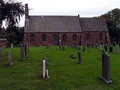
The village does have a church,; it lacks any other services or facilities. The nearest shops are located in the nearby town of Aspatria. The village has one small family shop, a phone box, a bench and a postbox.
There are no schools in Hayton, however there are 10 infant schools, 7 junior schools, 46 primary schools and 9 secondary schools in the Allerdale area in the surrounding towns of Maryport, Cockermouth, Keswick and Wigton which are within a 9 – 20-mile radius of Hayton. A number of the secondary schools take students through to the age of 18 which covers A-Level studies.
Transport
There is no local bus service and the nearest train station is 2.2 miles away at Aspatria. The M6 is 25 miles from the village, just beyond the city of Carisle.
Climate
Due to its location on the North West coast and the mountainous geography of the area, the Lake District is the wettest region in the UK. It receives on average over 2,000mm of rainfall every year however there local variation across the region. Typically in the area surrounding Hayton, the most rainfall occurs in the months February and October; with an average of 109mm in each month. The driest month is July with an annual average of 58mm however throughout the year there is average of 18 rainy/ drizzle days per month. Annual daytime temperatures range from 7 °C in February to highs of 17 °C in June and then 9 °C in November
History
To the north-east of the village lies Hayton Castle, which on 11 April 1967 was officially listed as a Grade I building.
The UK Census of 1881 gives clear indication of the main occupation of residents in Hayton and Mealo as the majority of the population was employed in agriculture. A number of farms remain, the main ones being; Hazel Mount at the bottom, south-west entrance to the village, and Grange Farm, Hayton Farm, Midtown Farm and Town Head Farm in the centre of the village.
There is also a PW – Place of Worship marked on some older maps however this building is not official named as an active place of worship but land use is clear with the gravestone visible from aerial photography.
On 22 June 1836 the Wigton Poor Law Union was established to represent 30 constituent townships and parishes of which Hayton & Mealo was included. To begin with, the new union operated in existing workhouses at Caldbeck, Oulton, Glasson and Wigton itself however in 1838 – 42, a new workhouse was constructed at Cross Lane – an 11-acre site – costing a total £323.16s.8d.
In 1870–72, John Marius Wilson's Imperial Gazetteer of England and Wales described Hayton as:
"A township and a chapelry in Aspatria parish, Cumberland; on the coast, 2½ miles W of Aspatria r. station. They have a post-office under Maryport. The township includes Mealo, and comprises 1,971 acres. Pop., 390. The chapelry was constituted in 1867. Pop., 1,095. The living is a rectory. Value, £300."
Toponymy
The origins of the name lie in Saxon times; Hay meaning 'animal feeding stalls' and Ton translating to 'house or farm'. This reflects the original function and main focus of employment in the area in years past, agriculture.