
Basin countries United States Surface elevation 2,499 m | Surface area 300 acres (120 ha) Area 121 ha | |
 | ||
Location Fort Apache Indian Reservation, Apache County, Arizona, United States | ||
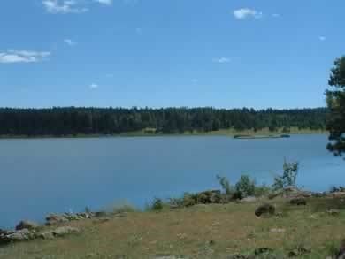
Hawley Lake is a 300-acre (120 ha) lake and place in east-central Arizona, in the White Mountain Apache Indian Reservation, and has an elevation of 8,200 feet (2,500 m).
Contents
Map of Hawley Lake, Arizona 85930, USA
The lake is a remnant of Pliocene volcanism on the Mogollon Rim but it has been artificially extended as a reservoir for downstream irrigation plus trout and ice fishing (though an $9 tribal licence is required to fish on the reservation). Its popularity as a recreational area is enhanced by a nearby ski resort.
ClimateEdit
Owing to its high altitude, Hawley Lake has a humid continental climate (Köppen Dsb) and stands as one of the coldest and wettest places in Arizona. Lake-effect snow gives it much heavier snowfall than nearby towns like Alpine and in March 1973 snowfall was as high as 105 inches (2.7 m). Rainfall from July to September is also high, though not exceptional compared to many parts of southeastern Arizona.
Hawley Lake holds the all-time record low temperature in Arizona history with −40 °F (−40 °C) recorded on January 7, 1971. It also holds the record for most precipitation in a calendar year in Arizona with 58.92 inches (1,496.6 mm) in 1978 – much of that being snow.