
Volcano Lake Taupo Type Ultra Plinian | Date about 180 AD VEI 7 | |
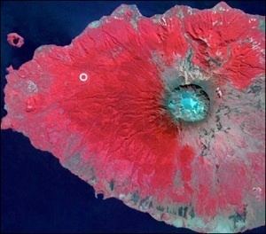 | ||
Impact Devastated local vegetation, expanded Lake Taupo, flooded the Waikato River | ||
The Hatepe eruption, named for the Hatepe Plinian pumice tephra layer, sometimes referred to as the Taupo eruption and dated to around 180 AD, was Lake Taupo's most recent major eruption. It is considered New Zealand's largest eruption during the last 20,000 years. The eruption ejected some 120 km3 (29 cu mi), a VEI 7 eruption, of which 30 km3 (7.2 cu mi) was ejected in the space of a few minutes. This makes it one of the most violent eruptions in the last 5000 years, comparable to the Minoan eruption in the 2nd millennium BC, the Tianchi eruption of Baekdu around 1000 AD and the 1815 eruption of Tambora. The resulting ash turned the sky red over Rome and China.
Contents
Stages of eruption
The eruption went through several stages, with six distinct marker horizons identified. Despite the uniform composition of the erupted magma, a wide variety of eruptive styles were displayed, including weak phreatomagmatism, Plinian eruptions, and a huge pyroclastic flow. Rhyolitic lava domes were extruded some years or decades later, forming the Horomatangi reefs and Waitahanui bank.
The main pyroclastic flow devastated the surrounding area, climbing over 1,500 m (4,900 ft) to overtop the nearby Kaimanawa Ranges and Mount Tongariro, and covering the land within 80 km (50 mi) with ignimbrite. Since New Zealand was not settled by the Māori until more than a thousand years later, the area had no known human inhabitants when the eruption occurred. Tsunami deposits of the same age have been found on the central New Zealand coast, evidence that the eruption caused local tsunamis, but much more widespread waves may have been generated (like those observed after the 1883 Krakatoa eruption).
The Hatepe eruption further expanded the lake that had formed after the much larger Oruanui eruption around 26,500 years ago. The previous outlet was blocked, raising the lake 35 metres above its present level until it broke out in a huge flood, flowing for more than a week at roughly 200 times the Waikato River's current rate.
Dating the event
The Taupo eruption was at one time dated to approximately 130 AD based on 14
C from carbonized vegetation enclosed in the eruption products. However, the 22 selected samples used to obtain an average date of 1,819 ± 17 years BP (131) had much larger standard deviations than the average date itself. Most if not all geologists now accept that the tephra or pumice fall from the eruption was far greater than previously thought, approximately 150 km3 (36 cu mi) instead of 14 km3 (3.4 cu mi). This means the event would have been visible from China and Rome. It was therefore posited by Colin J. N. Wilson et al. (and is now generally accepted) that the meteorological phenomena described by Fan Ye in Han China and by Herodian of Antioch in the Roman Empire were due to this eruption, which therefore can be dated exactly to 186 AD. However, recent radiocarbon dating by R. Sparks has put the date at 233 AD ± 13 (95% confidence).
Humans had not settled in New Zealand at the time, and would not for another thousand years. The nearest humans at the time were in Australia, more than 2,000 kilometres (1,200 mi) to the west.