
Elevation 510 ft (160 m) Parent range Metacomet Ridge Range Metacomet Ridge | Coordinates to Age of rock 200 Ma Easiest route Metacomet Trail | |
 | ||
Parent peak 41° 54' 20"N, 72° 45' 29"W Location East Granby, Connecticut Similar West Suffield Mountain, Metacomet Trail, Barn Door Hills, Farmington Mountain, Pinnacle Rock | ||
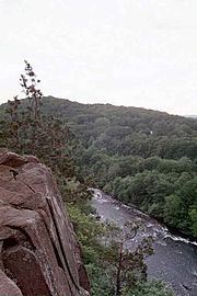
Hatchet Hill, est. 510 feet (160 m), is a trap rock ridge located in East Granby, Connecticut, 11 miles (18 km) northeast of Hartford, Connecticut. It is part of the narrow, linear Metacomet Ridge that extends from Long Island Sound near New Haven, Connecticut, north through the Connecticut River Valley of Massachusetts to the Vermont border. The southern edge of the ridge plunges nearly 200 vertical feet (61 m) into the Tariffville Gorge. The ridge is known for its rugged topography, unique microclimate ecosystems, rare plant communities, and as a seasonal raptor migration path. It is traversed by the 51-mile (82 km) Metacomet Trail.
Contents
- Map of Hatchet Hill East Granby CT 06026 USA
- GeographyEdit
- Geology and ecologyEdit
- Recreation and conservationEdit
- References
Map of Hatchet Hill, East Granby, CT 06026, USA
GeographyEdit
Roughly 2.5 miles (4.0 km) long by 0.75 miles (1.2 km) wide, Hatchet Hill is a collection of closely set tiered ridges and abrupt cliff faces with a high point of 510 feet (160 m). Its southern end is cut with steep cliffs at the Tariffville Gorge where the Farmington River gouges out a chasm between it and Talcott Mountain to the south. Also notable is Marsh Pond, a glacial kettle pond nestled in the center of the ridge. From Hatchet Hill, the Metacomet Ridge continues north as Peak Mountain and south as Talcott Mountain.
The northeast side of Hatchet Hill drains into the Connecticut River, thence to Long Island Sound; the rest of it into the Farmington River, thence to the Connecticut River.
Geology and ecologyEdit
Hatchet Hill, like much of the Metacomet Ridge, is composed of basalt, also called trap rock, a volcanic rock. The mountain formed near the end of the Triassic Period with the rifting apart of the North American continent from Africa and Eurasia. Lava welled up from the rift and solidified into sheets of strata hundreds of feet thick. Subsequent faulting and earthquake activity tilted the strata, creating the cliffs and ridgeline of Hatchet Hill. Hot, dry upper slopes, cool, moist ravines, and mineral-rich ledges of basalt talus produce a combination of microclimate ecosystems on the mountain that support plant and animal species uncommon in greater Connecticut. Hatchet Hill is also an important raptor migration path. (See Metacomet Ridge for more information on the geology and ecosystem of Hatchet Hill).
Recreation and conservationEdit
Although among the shortest of notable peaks along the Metacomet Ridge, the sharp topography of Hatchet Hill offers a number of scenic vistas culminating in the overlook atop the Tariffville Gorge. Hatchet Hill is traversed by the Metacomet Trail, (maintained by the Connecticut Forest and Park Association), which extends from the Hanging Hills of Meriden, Connecticut to the Massachusetts border.
The ridge is open to hiking, bird watching, snowshoeing and other passive pursuits.
The ecosystem and ridgeline of Hatchet Hill are most threatened by development and quarrying. In 2000, Hatchet Hill was included in a study by the National Park Service for the designation of a new National Scenic Trail now tentatively called the New England National Scenic Trail, which would include the Metacomet-Monadnock Trail in Massachusetts and the Mattabesett Trail and Metacomet Trail trails in Connecticut.
The East Granby Land Trust [1] has played an active part in the conservation of Hatchet Hill and its viewshed.