
Country Thailand Postal code 90110 Area 660.2 km² Province Songkhla Province | Time zone THA (UTC+7) Geocode 9011 Population 384,994 (2013) | |
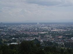 | ||
Hat Yai (Thai: หาดใหญ่) is a district (Amphoe) of Songkhla Province, southern Thailand.
Contents
Map of Hat Yai District, Songkhla, Thailand
Geography
Neighboring districts are (from the west clockwise) Khuan Kalong of Satun Province, and Rattaphum, Bang Klam, Khuan Niang, Singhanakhon, Mueang Songkhla, Na Mom, Chana, Sadao and Khlong Hoi Khong.
The northeastern part of the district is at the shore of the Songkhla Lake.
Administration
The district is subdivided into 13 subdistricts (tambon), which are further subdivided into 98 villages (muban). The city (thesaban nakhon) Hat Yai covers the whole tambon Hat Yai. There are 4 towns (thesaban mueang) - Ban Phru covers parts of tambon Ban Phru, and Khlong Hae, Khuan Lang and Kho Hong each cover the whole same-named tambon. There is further one township (thesaban tambon) - Pha Tong covers parts of tambon Pha Tong. The non-municipal areas are administrated by 9 Tambon administrative organizations (TAO).
Missing numbers are tambon which now form the districts Bang Klam and Khlong Hoi Khong.