
Population 2,420 (2011 Census) Civil parish Harbury Local time Thursday 1:29 PM Dialling code 01926 | OS grid reference SP3760 Sovereign state United Kingdom | |
 | ||
Weather 9°C, Wind SW at 18 km/h, 83% Humidity District Stratford-on-Avon District | ||
Harbury fields touring caravan site warwickshire
Harbury is a village and civil parish in the Stratford-on-Avon district of Warwickshire, England. It is about 3 miles (5 km) west-southwest of Southam and about 5 miles (8 km) southeast of Royal Leamington Spa. The parish includes the hamlet of Deppers Bridge. The 2011 Census recorded the parish's population as 2,420.
Contents
- Harbury fields touring caravan site warwickshire
- Map of Harbury Leamington Spa UK
- History
- Parish church
- Railway and cutting
- Harbury quarry
- Amenities
- Developments
- Notable residents
- References
Map of Harbury, Leamington Spa, UK
The village is on a ridge of lias up to 390 feet (119 m) high that runs roughly northeast – southwest. The parish covers 3,397 acres (1,375 ha). It is bounded by the River Itchen to the east, Fosse Way to the northwest, a minor road to the south and field boundaries on its other sides. Adjoining parishes are Bishop's Itchington, Bishop's Tachbrook, Chesterton, Ladbroke and Southam.
The A425 road and the Chiltern Main Line pass through the parish just north of Harbury village. Junction 12 on the M40 motorway is about 3 miles (5 km) south of the village.
History
Bronze Age cooking pots have been found in the area. Fosse Way is a major Roman Road.
The toponym "Harbury" is from Old English, said to be derived from Edgar, an early tribal leader. The Domesday Book of 1086 records the manor as Edburberie where it is listed amongst lands granted to Henry de Ferrers by William the Conqueror. The land employed five ploughs and was valued at £4.
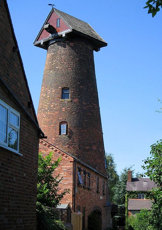
At the time of the Hundred Rolls in 1279 two windmills were recorded in the parish. The present brick-built tower mill in Mill Lane is late 18th-century. It is disused and has no sails.
The earliest known bridge over the Itchen at Deppers Bridge was built by the Lords of the Manor of Ladbroke. It is known to have existed by 1397, when it was out of repair and their lordships were ordered to have it renewed.
In 1611 the legacy of Thomas Wagstaff, late Lord of the Manor, established a school in the parish. An inscribed panel on the building records that his will was contested until settled by a Decree in Chancery in 1637. The former schoolhouse is an early 17th-century building of limestone, with mullioned and transomed windows, a schoolroom and Tudor fireplaces.
The cover of a silver chalice from the parish church is inscribed Harberbery 1576. Christopher Saxton's 1637 map of Warwickshire marks the village as Harberbury. An open field system prevailed in the parish until an Inclosure Act passed by Parliament in 1779 was implemented, enclosing 120 yardlands (3,600 acres (1,457 ha)) of common land.
The earliest known record of a post office in the village is from September 1847, when a type of postmark called an undated circle was issued.
Parish church
The Church of England parish church of All Saints has a 13th-century chancel with lancet windows. The southwest tower is later 13th-century, also with lancet windows. The south and north aisles and arcades were added in about 1300. The font and the embattled top of the tower are Georgian additions. In 1873 the church was restored and the south aisle widened and new Gothic Revival windows inserted in the east and north walls of the chancel. The stained glass in several of the windows is from the 1890s.
In 1811 Thomas II Mears of the Whitechapel Bell Foundry recast the tower's bells as a ring of five. This may be when the top of the tower was rebuilt in brick. In 1959 John Taylor & Co of Loughborough recast the bells as a ring of six, and in 1981 Taylor & Co cast a new treble and second bell, increasing the ring to eight.
The parish of All Saints is now part of the benefice of Harbury and Ladbroke.
Railway and cutting
Building of the Birmingham and Oxford Junction Railway between Birmingham and Fenny Compton through the parish started in 1847 and was completed in 1852. Southam Road and Harbury railway station opened that year, at Deppers Hill about 1 mile (1.6 km) east of the village. By the time the line opened in 1852 it was part of the Great Western Railway. In 1948 it was nationalised as part of British Railways, which closed the station to goods traffic in 1963 and passenger traffic in 1964. The station has since been demolished. The railway remains open as part of the Chiltern Main Line, carrying both Chiltern Railways and CrossCountry passenger trains and much freight traffic.
The railway passes through the ridge northeast of the village. Originally a tunnel was planned, but its geology of Jurassic Blue Lias proved too unstable. Instead a cutting up to 110 feet (34 m) deep was dug between 1847 and 1852, which in 1850 was described as "one of the deepest in the Kingdom, being 104 feet deep and 600 wide". There is a tunnel, but for a distance of only 73 yards (67 m) through a high part of Deppers Hill where there is a road junction. The tunnel portals were built with high retaining walls to protect them from subsidence.
Parts of the cutting have suffered subsidence a number of times. In 1884 the GWR widened the cutting to make its slopes shallower in the hope of preventing further slips. On 14 February 2014 part of the cutting at the end of the tunnel near Bishop's Itchington subsided. All train services were suspended for several days while Network Rail worked to clear the damaged section of slope and try to stabilise it.
Network Rail was still working on the cutting by 31 January 2015 when part of it subsided again, and again the line had to be closed to all train services. The next day it announced that about 350,000 tons of unstable rock and earth would have to be removed, and assessment of the site before clearance could start could take several days. On 3 February Network Rail chairman Mark Carne described the landslip as "a massive incident" and said the line may be closed for "several weeks". A fortnight later NR announced that it would reopen the railway "by Easter", i.e. 2 April. On 4 March it brought the reopening date forward by three weeks to 13 March.
Harbury quarry
As well as linking Birmingham and Oxford, the new railway provided a connection for the Greaves Works in Bishop's Itchington that since 1820 had been quarrying Blue Lias and turning it into cement. The business became Greaves, Bull and Lakin and in 1855 opened a new cement works. Production increased in phases over the next seven decades, and quarrying extended across the parish boundary into Harbury. Allied Cement Manufacturers, makers of Red Triangle Cement, bought the quarry and works in 1927 but went bankrupt in 1931. Associated Portland Cement, now Blue Circle Industries, bought ACM's assets in 1932 and continued production. Cement-making was ended in 1970 and the site was turned into a depot. The site was cleared in 1994.
Blue Lias is a Lower Jurassic marine sediment that also forms the unstable sea cliffs at Lyme Regis on the Dorset coast. As at Lyme Regis, the Blue Lias at Harbury is rich in marine fossils. In 1927 and 1928 the skeletons of two marine reptiles were found in Harbury quarry. They are an ichthyosaur and a plesiosaur, and both fossils are now in the Natural History Museum, London.
The deep quarries on the Harbury side of the parish boundary have since been converted into Bishops Bowl Lakes, which is a coarse fishing facility.
Amenities
Harbury has a primary school with about 200 pupils. A day nursery provides childcare for children aged 3 months to 5 years. A pre-school provides sessional early years education for children aged 2 yrs 9 months to school entry. The village has a GP's practice and a volunteer-run public library.
The village has four pubs: The Crown Inn, The Gamecock, The Old New Inn and the Shakespeare Inn. Another pub, the Dog Inn, closed in 2012 and its future is now uncertain. There is a village hall and a separate Harbury Village Club.
There is a recreation ground and playing field behind the village hall with a playground, netball court, football pitches, the 60 Seconds Arena and a skate park. The recreation ground has three tennis courts that are used by the village tennis club. Harbury has a Rugby football club with its own ground and clubhouse, which it shares with the village Cricket Club. The village has also a junior football club.
There is a number of shops, including a pharmacy, a greengrocer and two supermarkets, one being a branch of the Co-Op and the other having a sub-post office. Harbury has an independent garage and a filling station.
Developments
Follett Property Holdings Ltd, owners of the Harbury Estate, propose to build a housing estate and a business park. There have also been proposals for a new Harbury railway station; however it is believed that the current railway infrastructure has not enough capacity for this. Harbury Parish Council and Stratford District Council are reviewing the proposals.