
Length 150 km | Source Alborz | |
 | ||
Main source Central Alborz≈ 3,500 m (11,500 ft) Bridges Davazdah Cheshmeh, Moalagh Bridge | ||
The Haraz River (Persian: هراز) is a notable river flowing through the Mazandaran Province of northern Iran. It flows northwards, from the Alborz mountain range into the Caspian Sea.
Contents
Map of Haraz, Iran
Course
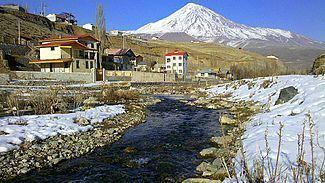
The Haraz River originates at the foot of Mount Damavand in Larijan District, the highest peak of the Alborz Range. From its mountain source, it flows down into the Haraz River Valley, into the city of Amol, and onto its river mouth in the southern Caspian Sea between the towns of Fereydoon Kenar in Fereydunkenar County and Mahmood Abad in Mahmudabad County.
Haraz River Valley
Road 77 (Haraz Road) follows the river over the Hashem Pass and through the valley, and is the most important road from Tehran to the Caspian coast. It also provides access to Lar National Park, and is the nearest road to Mount Damavand, which at 5,610 metres (18,410 ft) is the highest peak in Iran and the Middle East region.