
Affiliation Agricultural Union | Founded 1984–1989 Population (2015) 113 | |
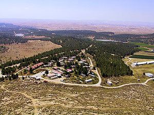 | ||
Har Amasa (Hebrew: הַר עֲמָשָׂא, lit. Mount Amasa) is a communal settlement in the south of Israel. Located near the Yatir Forest 20 kilometres south of Hebron and 14 km northeast of Arad, it is the only member of the Tamar Regional Council to be located in the highlands outside the Jordan Rift Valley. In 2015 it had a population of 113.
Contents
Map of Har Amasa, Israel
It was named after the nearby Mount Amasa (859 m), which was in turn named after Amasa son of Ithra the Israelite (2 Samuel 17:25).
History
The village was initially founded as a Gush Emunim settlement, from a government decision made on September 14, 1980. It was handed over to the kibbutz of the United Kibbutz Movement on June 30, 1983. It gradually changed its operations over the next 20 years. In 2003, it was transferred to the authority of the Agricultural Union movement, and it was preparing to expand to include many new residents in a less formal framework, while still preserving its social fabric.
In 2006, Ynet reported that the kibbutz was undergoing a religious conversion through Chabad. According to certain members of the kibbutz, the reason was that they were abandoned by the Kibbutz Movement that purposely kept their status as a "kibbutz under construction" in order to receive its funding. The movement denied the allegations and stated that the religious converts were new residents. In 2006, the kibbutz members sent a petition to the High Court of Justice to transfer the village's administration to them and remove the "under construction" status, instead of being administered by the Kibbutz Movement.