
Local time Wednesday 4:48 PM | ||
 | ||
Weather 14°C, Wind SW at 10 km/h, 65% Humidity | ||
Hamstead Marshall is a village and civil parish in the English county of Berkshire. The Village is located within the North Wessex Downs. The road signs' name and that accepted by most of the village's organisations is Hamstead Marshall, an alternative Hampstead Marshall was preferred from time to time and remains the official name of the civil parish. The population of this civil parish at the 2011 Census was 275.
Contents
Map of Hamstead Marshall, Newbury, UK
Location and amenities
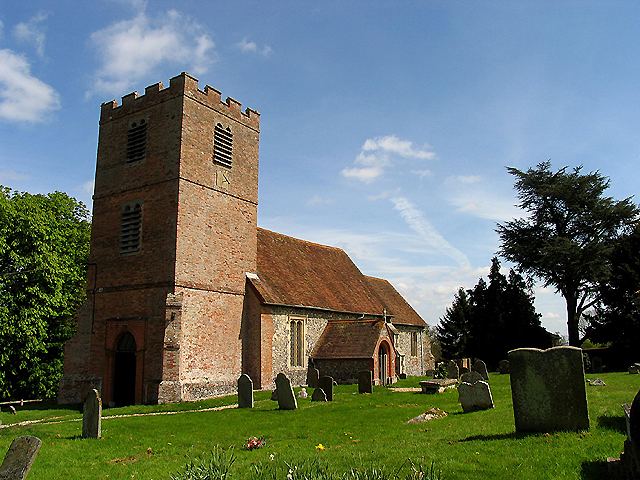
In the west of West Berkshire (a unitary authority area), south-west of Newbury, on the Berkshire-Hampshire border, the parish covers 7.78 square kilometres (3.00 sq mi), having lost territory in a boundary change of 1991. The village contains scattered settlements such as Ash Tree Corner, Chapel Corner, Holtwood and Irish Hill. There is a 12th-century church (St Mary's), a village hall, a public house called the White Hart, a Dogs Trust canine rescue kennels and the Organic Research Centre at Elm Farm.
History
Hamstead Marshall has three sites of medieval motte-and-bailey castles, all on private land, with one a possible site of Newbury Castle. All are registered historic monuments.
A lesser alternative name Hampstead Marshall was preferred from time to time and remains the official name of the civil parish.
William Marshall who became Earl of Pembroke, was a loyal knight to four kings: Henry II, Richard I, King John, and Henry III of England and this is when the Marshall suffix was added to the village. The manor continued to be owned and used by kings and queens throughout the centuries, until it was sold in 1613.
The village was from 1620 until the 1980s the seat of the Earls of Craven. William Craven, 1st Earl of Craven (1608-1697) built a mansion there, originally intended as a residence for Charles I's sister, Elizabeth of Bohemia, although she died before construction began. It burnt down in 1718. The Cravens later expanded a hunting lodge to live in instead, and this still stands, privately occupied, in the centre of Hamstead Park. Until the mid-twentieth century the Craven family owned most of the village, but successive sales by the estate have made owner-occupancy slightly greater than the proportion of rented property.
Geography
The village landscape comprises farmland, woodland and parkland. No A or B roads dissect this but Hamstead Marshall has bus services. The river Kennet and the Kennet and Avon Canal pass through the northern edge of the village, and the river Enborne marks the southern boundary. About half the property pre-dates 1900, and 32 buildings or structures such as walls are listed under the national planning law and conservation legislation.
The village has four areas that are considered sites of Special Scientific Interest (SSSI), these are Hampstead Marshall Pit, Irish Hill Copse, Redhill Wood and the River Kennet.