OS grid reference SO747864 Post town BRIDGNORTH Local time Wednesday 4:12 PM | Sovereign state United Kingdom Postcode district WV15 Dialling code 01746 Civil parish Quatt | |
 | ||
Weather 16°C, Wind SW at 11 km/h, 55% Humidity | ||
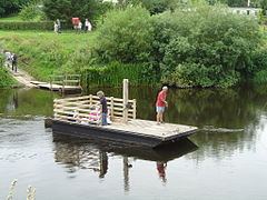
Hampton Loade is a hamlet in Shropshire, England along the Severn Valley. It is situated on the east bank of the River Severn at grid reference SO747864, and is notable for the unusual current-operated Hampton Loade Ferry, a cable ferry to the hamlet of Hampton on the west bank. The ferry is responsible for Hampton Loade's name, as Loade is derived from lode, an old English word for ferry.
Contents
Map of Hampton Loade, Bridgnorth, UK
The village is in the post town district of Wolverhampton and local government district of Bridgnorth, 4 miles to the north. It is in the Ludlow parliamentary constituency and the West Midlands European parliament constituency.
Hampton Loade station, on the preserved Severn Valley Railway, is actually located on the Hampton side of the river.
There is an unusual bridge close to Hampton Loade: a small private roadway is suspended below two large waterpipe arches.
The village is also home to a satellite navigation error where the ferry is listed as a car ferry on certain sat-nav systems. A number of motorists using sat-nav units were misled by the error and drove off the jetty and into the river. Although there are now road signs in place warning of the error on approaching the village.
Landslide of June 2007
On the night of 19 June 2007, the village of Hampton on the west bank suffered major damage as a result of a severe rainstorm. The one and only road into the village was washed away (BBC photo), and large sections of nearby Severn Valley Railway track subsided.
