
Named for John Hampden Congressional districts 1st, 2nd Website www.pvpc.org Founded 1812 County seat Springfield | Largest city Springfield Time zone Eastern: UTC-5/-4 Area 1,642 km² Population 467,319 (2013) | |
 | ||
Points of interest Naismith Memorial Basketball Hall of Fame Colleges and Universities Western New England, Westfield State University, Springfield Technical Communi, American International College, Holyoke Community College Destinations Springfield, Westfield, Holyoke, Holland, Chicopee | ||
We buy houses cash in hampden county massachusetts
Hampden County is a non-governmental county located in the Pioneer Valley of the state of Massachusetts, in the United States. As of the 2010 census, Hampden County's population was 463,490. Its traditional county seat is Springfield, the Connecticut River Valley's largest city, and economic and cultural capital. Hampden County was split from Hampshire County in 1812, because Northampton, Massachusetts was made Hampshire County's "shire town" in 1794; however, Springfield—theretofore Hampshire County's traditional shire town, dating back to its founding in 1636—grew at a pace far quicker than Northampton and was granted shire town-status over its own, southerly jurisdiction. It was named for John Hampden. To the north of Hampden County is modern-day Hampshire County; to the west is Berkshire County; to the east is Worcester County; to the south are Litchfield County, Hartford County, and Tolland County in Connecticut.
Contents
- We buy houses cash in hampden county massachusetts
- Map of Hampden County MA USA
- Law and government
- Geography
- Adjacent counties
- National Parks
- 2010 census
- Income
- Greater Springfield
- Cities
- Census designated places
- City neighborhoods
- References
Map of Hampden County, MA, USA
Hampden County is part of the Springfield, MA Metropolitan Statistical Area. It is the most urban county in Western Massachusetts. The Knowledge Corridor surrounding Springfield-Hartford is New England's second most populous urban area (after Greater Boston) with 1.9 million people.
Law and government
Like an increasing number of Massachusetts counties, Hampden County exists today only as a historical geographic region, and has no county government. All former county functions were assumed by state agencies in 1998. The sheriff and some other regional officials with specific duties are still elected locally to perform duties within the county region, but there is no county council, county commission or other county governing body. Communities are now granted the right to form their own regional compacts for sharing services. Hampden County and Hampshire County together are part of the Pioneer Valley Planning Commission.
See also: MassGov page on counties.
Geography
According to the U.S. Census Bureau, the county has a total area of 634 square miles (1,640 km2), of which 617 square miles (1,600 km2) is land and 17 square miles (44 km2) (2.7%) is water.
Adjacent counties
National Parks
2010 census
As of the 2010 United States Census, there were 463,490 people, 179,927 households, and 115,961 families residing in the county. The population density was 751.0 inhabitants per square mile (290.0/km2). There were 192,175 housing units at an average density of 311.4 per square mile (120.2/km2). The racial makeup of the county was 76.5% white, 9.0% black or African American, 2.0% Asian, 0.4% American Indian, 0.1% Pacific islander, 9.2% from other races, and 2.9% from two or more races. Those of Hispanic or Latino origin made up 20.9% of the population. In terms of ancestry, 17.4% were Irish, 11.0% were Polish, 10.8% were Italian, 8.8% were English, 6.0% were German, 5.5% were French Canadian, and 2.6% were American.
Of the 179,927 households, 32.6% had children under the age of 18 living with them, 41.9% were married couples living together, 17.5% had a female householder with no husband present, 35.6% were non-families, and 29.2% of all households were made up of individuals. The average household size was 2.49 and the average family size was 3.09. The median age was 38.6 years.
The median income for a household in the county was $47,724 and the median income for a family was $61,061. Males had a median income of $50,207 versus $37,765 for females. The per capita income for the county was $24,718. About 13.2% of families and 17.2% of the population were below the poverty line, including 26.5% of those under age 18 and 11.2% of those age 65 or over.
Income
The ranking of unincorporated communities that are included on the list are reflective if the census designated locations and villages were included as cities or towns. Data is from the 2007-2011 American Community Survey 5-Year Estimates.
Greater Springfield
Hampden County is the economic and cultural center of Western Massachusetts - a region that spans Massachusetts' three counties in the Connecticut River Valley, and its mountainous, westernmost county, The Berkshires. Western New England's largest city, and Western Massachusetts' economic, civic, and recreational capital is Springfield. Springfield lies on the Connecticut River.
Springfield has played an important role throughout American history. Today, it features numerous sites of historic and general interest. As of 2011, Springfield is also several years into an economic and cultural resurgence that began during the new millennium, in conjunction with Springfield and Hartford, Connecticut - which is located only 23.9 miles (38.5 km) south—forming the Knowledge Corridor metropolitan region. The two cities which once competed for similar businesses have, in the past decade, taken on more complementary roles, with Hartford increasingly defining itself as a business center and Springfield increasingly defining itself as a recreational center. Whereas Hartford features a post-modern skyline and relatively wider thoroughfares, Springfield has retained its human-scale, Victorian architecture and features and increasingly lively Metro Center.
Worldwide, Springfield is best known as the birthplace of the sport of basketball. The Basketball Hall of Fame sits on its riverfront in a $45 million shrine built in 2003. Previous to basketball's popularity boom in the 1980s, Springfield was best known as the site of the Springfield Armory, a site selected by George Washington and Henry Knox in 1777. Closed controversially during the Vietnam War, the Springfield Armory National Park features the largest collection of historic firearms in the world, and has been the site of numerous technical innovations—including the first uses of interchangeable parts and assembly line mass production. The Springfield Armory helped to give Springfield its nickname, "The City of Firsts," catalyzing developments like the lathe, (Thomas Blanchard, 1819;) the first, American car (1825, Thomas Blanchard;) numerous editions of the Springfield rifle; the gasoline-powered automobile, (1893, the Duryea brothers;) the first successful motorcycle, (1901, "Indian" motorcycle;) and the first modern fire engine and fire department, (1905 & 1907, Knox Automobile and the Springfield Fire Department.)
Other Springfield attractions include the Quadrangle, with an impressive museum and outdoor sculpture complex, particularly for a city of only 160,000 residents. The Quadrangle includes five museums located around the Dr. Seuss Memorial sculpture garden—featuring, in particular, two world-class art museums and one world-class science museum that includes the first U.S. planetarium. The site also features one of Augustus Saint-Gaudens most famous outdoor bronze statues, The Puritan, depicting early Springfield settler, Deacon Samuel Chapin.
Forest Park near the southern border of the city, is, at 735 acres, one of the largest urban parks in the United States. It was designed in 1891 by Frederick Law Olmsted, the designer of New York City's Central Park.
Springfield is a city of festivals, featuring a festival nearly every week during the warmer months, and at least monthly during the cooler months. Regardless of the time of year, Springfield's 60-establishment Club Quarter is features bars, discos, restaurants, live music, comedy, and theater. The innovative Springfield Symphony Orchestra plays in a Greek Revival Symphony Hall renowned for its "perfect acoustics." One can watch off-Broadway plays at City Stage on Main Street, or see live comedy at Rascal's at Monarch Place.
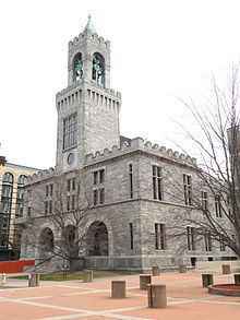
Most of Springfield's sites are located in its Metro Center district; however, its famous "City of Homes" architecture is found mostly in neighborhoods like Forest Park, the neighborhood surrounding the park—and the Quadrangle-Mattoon Street Historic District. The heart of Springfield is Court Square, across from which is the MassMutual Center, named for the Fortune 100 company located in Springfield's Pine Point neighborhood. Springfield is also home to six universities: Springfield College, American International College, Western New England University, Tufts University School of Medicine, UMass Amherst's School of Urban Design, and Springfield Technical Community College, which draw over 20,000 university students to the city annually.
The City of Agawam, across the South End bridge from Springfield, is the site of Six Flags New England, which is located beside the Connecticut River. Six Flags New England features 11 roller coasters, including the #1 ranked roller-coaster in the world, the Bizarro. It also features a large water park and seasonal events. Excepting Six Flags New England, Agawam is mostly suburban in character.
The Town of West Springfield - technically a city under Massachusetts law - across the Springfield Memorial Bridge and North End Bridge from Springfield, features a mix of urban and suburban development. Its most prominent cultural attraction is the New England States' collective State Fair, The Big E—the only U.S. fair that includes the participation of more than one state. The 6th largest agricultural fair in the United States, the Big E features rides, games, food, animal shows and various other exhibits. The Avenue of the States features replica state houses of all six New England State Houses, each of which is owned by the particular state. During the Big E, which generally lasts from September 15-October 1 each year, these buildings serve as consulates representing each New England state. Also, the Big E features Storrowton Village, a replica 19th century New England village.
The Town of Longmeadow, bordering Springfield to the south, is the region's most affluent suburb. It is the site of Bay Path College, and dozens of historic homes along Longmeadow Street.
The City of Chicopee, bordering Springfield to the north, is home to Westover Air Reserve Base and Westover Metropolitan Airport, Hampden County's largest airport. (Bradley International Airport, the Hartford-Springfield area's largest airport, sits 12 miles south of Springfield in Windsor Locks, Connecticut.) Chicopee hosts the Catholic Elms College, and features a mix of urban and suburban developments.
The City of Westfield features Westfield State University, an institution founded by the renowned education reformer Horace Mann. It was the first institution in the country to admit people regardless of sex, race, age, religion, or economic status. Westfield too features a mix of urban, suburban, and even rural development—at 48 square miles, it is the largest place in Western Massachusetts. (Plymouth is the largest place in Massachusetts at 96 square miles.)
The City of Holyoke—one of the first planned, industrial cities in the United States—features the Holyoke Canal System and numerous bars and nightclubs downtown. As of 2011, Holyoke is in the early stages of an urban revitalization, with high-tech and water power catalyzing its resurgence. Interestingly, while the City of Holyoke currently has a predominately Puerto Rican population, it hosts the second largest St. Patrick's Day parade in the United States, attracting over 400,000 people annually. The city is also home to Holyoke Community College, which educates approximately 6,500 students.
Other towns in Hampden County are located either in the "Springfield Mountains" to the east of the city, or in the foothills of The Berkshires, to the west of the city. Predominately suburban or rural in character, each of these towns feature unique histories and sites. For example, Ludlow, Massachusetts features a large and centralized Portuguese diaspora. Palmer, Massachusetts is a well-known railroad town.
Cities
Census-designated places
City neighborhoods
The following are neighborhoods located in Springfield or West Springfield.