
Province Ontario | ||
 | ||
Similar Bayfront Park, Royal Botanical Gardens, Desjardins Canal, HMCS Haida, Burlington Bay James N Allan S | ||
Carp fishing canada hamilton harbour lake ontario sep 7 2016
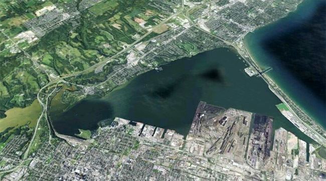
Hamilton Harbour, formerly known as Burlington Bay, lies on the western tip of Lake Ontario, bounded on the northwest by the City of Burlington, on the south by the City of Hamilton, and on the east by Hamilton Beach (south of the Burlington Bay James N. Allan Skyway) and Burlington Beach (north of the channel). It is joined to Cootes Paradise by a narrow channel formerly excavated for the Desjardins Canal. Within Hamilton itself, it is referred to as "Hamilton Harbour", "The Harbour" and "The Bay". The bay is naturally separated from Lake Ontario by a sand bar. The opening in the north end was filled in and channel cut in the middle for ships to pass. The Port of Hamilton is located on the Hamilton side of the harbour.
Contents
- Carp fishing canada hamilton harbour lake ontario sep 7 2016
- Map of Hamilton Harbour Ontario Canada
- Ontario travel a hamilton harbour tour downtown guelph and
- History
- Randle Reef Coal Tar Deposit
- Trivia
- Infrastructure
- References
Map of Hamilton Harbour, Ontario, Canada
Ontario travel a hamilton harbour tour downtown guelph and
History
The bay was named in 1792 by John Graves Simcoe, the first lieutenant governor of Upper Canada, for the former name of the town of Bridlington in the East Riding of Yorkshire, England. Access to the bay was important for the early water transportation and industrial development of the area, including Dundas, Ontario, which had an early but ultimately unrealized lead over both Burlington (Brant's Block) and Hamilton.
Over the years, the bay was roughly treated by its littoral residents. Constant infilling, particularly in the North End of Hamilton, damaged fresh water streams and the wildlife they supported. Channel dredging tended to stir up natural and unnatural sediments, further disrupting the ecological land balance in the area. Chemical, industrial and thermal pollution, especially as a byproduct of the burgeoning steel industry after the 1890s, continued to degrade the environment.
The water ways in Hamilton have not always been polluted. The north-end of the Harbour used to be a regular swimming spot for working-class families. The pollution of Hamilton Harbour water ways is caused by industrialization and, by proxy, urbanization which came to be a major problem by 1917. Many working-class families were overcome by health hazards when dumping sewage into the inlets and the bay itself became a regular occurrence. Laurel Sefton MacDowell writes in her book An Environmental History of Canada that, “As early as the 1860s, a fishery inspector at Hamilton Harbour discovered that fish found along the shore tasted of coal oil and that dead ducks and muskrats were coated with oil from two refineries.” By the 1950s, city officials had deemed Hamilton Harbour unfit for any recreation use and shut down all beaches.
In 1919, a Federal Order-In-Council changed the name of Burlington Bay to Hamilton Harbour.
By the 1970s, the International Joint Commission, which governs water usage in the Great Lakes Basin, and other agencies began to recognize the need for action. Greater water quality awareness, improved pollution controls, and an economic downturn all served to improve conditions in the 1980s. In the 1990s, beautification and ecological control were well underway. These measures included sealing the Lax Lands, contaminated with heavy metals and other pollutants, under a cap of clay; landscaping Bayfront Park and Pier 4 Park; and keeping common carp from entering Cootes Paradise. The visible and measurable improvement in water quality in Burlington Bay was showcased in 1994 by the very public swim of Sheila Copps, a local MP and federal cabinet minister. Access and recreational use of the bayfront has improved, and swimming is now allowed at two beaches in the harbour - Bayfront and Pier 4.
Hamilton Harbour is listed as a Great Lakes Areas of Concern in The Great Lakes Water Quality Agreement between the United States and Canada. Part of the remediation plan is to reclaim the harbour's wetlands.
Randle Reef Coal Tar Deposit
Randle Reef, a site in the harbour, is considered the most dire of identified water pollution issues awaiting remediation in Canada. Sixty hectares in size, it contains 695,000 cubic metres of contaminated sediment at the bottom of the harbour. The clean-up project will cost $138.9 million and will be completed in 2022. Environment and Climate Change Canada, and the Ontario Ministry of the Environment and Climate Change, have each committed $46.3 million, with the final third of funding coming from the City of Hamilton, the City of Burlington, Halton Region, the Hamilton Port Authority, and U.S. Steel Canada.
Trivia
The bay is thought by some to host a North American cryptid, described by witnesses as a large snake-like creature. A diver drowned in the bay during the filming of a low-budget horror film titled Marina Monster on August 21, 2005.
Infrastructure
The bay today is crossed by two highways: 403 & Queen Elizabeth Way (QEW). The Burlington Bay James N. Allan Skyway (nicknamed "The Skyway") bridge, part of the QEW, crosses the border between Hamilton Harbour and Lake Ontario. The 403, York Street and a number of railways cross Hamilton Harbour on an glacial sandbar (similar in formation to the present day beach strip to the east) and separates Cootes Paradise from Hamilton Harbour.