
Country United States FIPS code 27-26630 Area 80 ha Zip code 56548 Local time Wednesday 3:41 AM | Time zone Central (CST) (UTC-6) GNIS feature ID 0644588 Elevation 266 m Population 576 (2013) Area code 218 | |
 | ||
Weather -11°C, Wind S at 13 km/h, 74% Humidity | ||
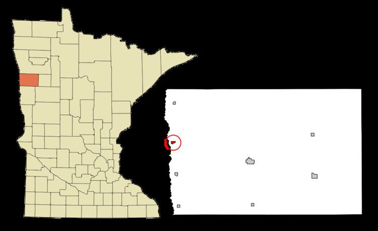
Halstad is a city in Norman County, Minnesota, United States. The population was 597 at the 2010 census.
Contents
Map of Halstad, MN 56548, USA
History
A post office called Halstad has been in operation since 1884. The city was named for Ole Halstad, a Norwegian settler.
Geography
According to the United States Census Bureau, the city has a total area of 0.31 square miles (0.80 km2), all of it land.
The Highway 200 bridge that crosses the Red River was replaced in the late 1990s, after constant flooding found it under water and impassable. Directly across the Red River on the North side of Highway 200, a small pond called Grandin Lake has provided the only close example of a freshwater ecosystem that is not a river. The table top topography of this region is impressive. There are regions of the Red River that have a one-inch change in elevation per mile.
2010 census
As of the census of 2010, there were 597 people, 251 households, and 139 families residing in the city. The population density was 1,925.8 inhabitants per square mile (743.6/km2). There were 306 housing units at an average density of 987.1 per square mile (381.1/km2). The racial makeup of the city was 94.0% White, 0.2% African American, 2.8% Native American, 0.8% from other races, and 2.2% from two or more races. Hispanic or Latino of any race were 4.7% of the population.
There were 251 households of which 27.1% had children under the age of 18 living with them, 43.0% were married couples living together, 10.0% had a female householder with no husband present, 2.4% had a male householder with no wife present, and 44.6% were non-families. 39.0% of all households were made up of individuals and 19.1% had someone living alone who was 65 years of age or older. The average household size was 2.23 and the average family size was 3.01.
The median age in the city was 46.6 years. 24.3% of residents were under the age of 18; 5.9% were between the ages of 18 and 24; 18% were from 25 to 44; 27% were from 45 to 64; and 24.8% were 65 years of age or older. The gender makeup of the city was 49.2% male and 50.8% female.
2000 census
As of the census of 2000, there were 622 people, 249 households, and 154 families residing in the city. The population density was 2,131.3 people per square mile (828.1/km²). There were 295 housing units at an average density of 1,010.8 per square mile (392.8/km²). The racial makeup of the city was 94.37% White, 0.16% African American, 1.45% Native American, 2.41% from other races, and 1.61% from two or more races. Hispanic or Latino of any race were 10.13% of the population.
There were 249 households out of which 26.9% had children under the age of 18 living with them, 53.4% were married couples living together, 6.4% had a female householder with no husband present, and 37.8% were non-families. 36.5% of all households were made up of individuals and 21.3% had someone living alone who was 65 years of age or older. The average household size was 2.26 and the average family size was 2.95.
In the city, the population was spread out with 23.2% under the age of 18, 4.5% from 18 to 24, 19.0% from 25 to 44, 23.3% from 45 to 64, and 30.1% who were 65 years of age or older. The median age was 47 years. For every 100 females there were 81.9 males. For every 100 females age 18 and over, there were 79.7 males.
The median income for a household in the city was $31,875, and the median income for a family was $43,750. Males had a median income of $38,594 versus $21,354 for females. The per capita income for the city was $15,918. About 8.9% of families and 11.1% of the population were below the poverty line, including 11.0% of those under age 18 and 9.6% of those age 65 or over.
Transportation
U.S. Route 75 and Minnesota State Highway 200 are two of the main routes in the community.