
Type Public park Created 1856 (1856) Area 161 ha | Location Christchurch Status Open all year Phone +64 20 4137 2299 | |
 | ||
Operated by Christchurch City Council Address 14 Riccarton Avenue, Christchurch Central, Christchurch 8011, New Zealand Hours Open today · Open 24 hoursWednesdayOpen 24 hoursThursdayOpen 24 hoursFridayOpen 24 hoursSaturdayOpen 24 hoursSundayOpen 24 hoursMondayOpen 24 hoursTuesdayOpen 24 hours Similar Canterbury Museum - Christchurch, Quake City, International Antarctic Centre, Cardboard Cathedral, TranzAlpine | ||
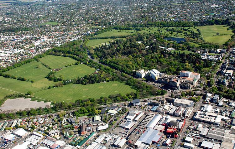
Hagley Park is the largest urban open space (164.637 hectares) in Christchurch, New Zealand, and was created in 1855 by the Provincial Government. According to the government's decree at that time, Hagley Park is "reserved forever as a public park, and shall be open for the recreation and enjoyment of the public." Hagley Park is characterised by its trees and broad open spaces. Hagley Park was named after Hagley Park, the country estate of Lord Lyttelton, who became chairman of the Canterbury Association in March 1850.
Contents
Hagley park
Location
The boundaries of the park, which is located in the central city of Christchurch, are defined by both the Avon River and the surrounding roadways. The longest road boundary is that along Deans Avenue on the western side adjacent to the suburb of Riccarton.
To the north and northeast, the natural path of the Avon River bounds the park. Moorhouse Avenue and Hagley Avenue form the south and south-eastern boundaries, respectively. Along the eastern boundary, the Park is defined by the two kilometre loop of the Avon River, which extends into the side of Hagley Park.
The Christchurch Botanic Gardens (21.14 hectares) are located within this loop and frequent bridges provide connections. The Botanic Gardens contain a collection of beautiful flowers and trees from around the world. The gardens attract many birds to the park, and sightseers frequently visit the park to view the plants and the wildlife.
The Canterbury Museum and Christ's College are the two other land uses that take up the balance of the land within the river's loop.
Two major avenues subdivide the park into three units. The northern unit is Little Hagley Park (6.96 hectares), with North Hagley Park (87.17 hectares) lying to the south of Harper Avenue. South Hagley Park (70.507 hectares) lies to the south of North Hagley Park, separated by Riccarton Avenue.
Road proposals
At various times, it was proposed to build additional roads through the park. In the 1860s, it was considered to connect Armagh Street with the Great South Road (now called Riccarton Road).
Usage
In its early days, Hagley Park was used for horse races. Hagley Park has frequently been a site for gathering large crowds together: it served as the location for the Great Industrial Exposition of 1882 and the New Zealand International Exhibition in 1906–1907. In 1906, the Australasian tennis championships (now known as the Australian Open) were held in Hagley Park as part of the Grand Slam. The singles event was won by Tony Wilding, who defeated Francis Fisher in three sets.
In recent years, the park has hosted many visiting circuses and open-air concerts. The Ellerslie Flower Show has been held in North Hagley Park since 2008.
A golf course (Hagley Golf Club) is located in North Hagley Park.
South Hagley Park contains several netball courts, the Hagley Oval cricket ground and a heliport for Christchurch Hospital.