
Place name Risingham Country England | UK-OSNG reference NY891861 | |
 | ||
Architectural style Ancient Roman architecture Similar Bremenium, Vindobala, Vindomora, Alauna, Camboglanna | ||
La zarzuela 07 04 2013 premio habitancum manhaj turfeiros galegos
Habitancum was an ancient Roman fort (castra) located at Risingham, Northumberland, England. The fort was one of the defensive structures built along Dere Street, a Roman road running from York to Corbridge and onwards to Melrose.
Contents
- La zarzuela 07 04 2013 premio habitancum manhaj turfeiros galegos
- Presentaci n valiant blue habitancum
- Location
- Description
- Garrison
- Current site
- References
The fort's name, Habitancum, is mentioned in the Ravenna Cosmography, but not in the Notitia Dignitatum, or other sources. Habitancum is also the name on an altar set up by Marcus Gavius Secundinus a consular beneficiary on duty there.
Presentaci n valiant blue habitancum
Location
The fort is situated 13 miles (21 km) north of Corbridge (Coria) and 8 miles (13 km) south of Rochester (Bremenium), the next Roman fort on Dere Street. It is west of the A68 road between Corbridge and Jedburgh, where the road crosses the River Rede at the village of West Woodburn. At this point Dere Street deviates westwards of the A68 and rejoins it a mile or two further north.
Description
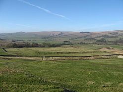
The fort occupies a low mound overlooking the River Rede. It is oblong in shape and measures 450 feet (140 m) north to south, and 400 feet (120 m) east to west, giving an area of just over 4 acres (16,000 m2). It was surrounded by a number of ditches, which can still be seen on the south and west sides.
The fort had gates in the south and west walls. There may have been gates in the other walls but no sign of them has been found. The walls were of sandstone ashlar, backed by a clay bank thirty feet thick.
At the end of the 2nd century the fort was either abandoned or destroyed when large numbers of Roman troops were withdrawn. Later, the fort was rebuilt by the First Cohort of Vangiones, one thousand strong.
Garrison
The 2nd-century garrison is not known for certain, but may have been the Fourth Cohort of Gauls. The 3rd-century garrison was the First Cohort of Vangiones, as well as a Numerus Exploratorum (Unit of Scouts) and a detachment of Raeti Gaesati (pikemen).
Current site
The only visible stone remains lie at the north-eastern corner angle, but the outlines of many buildings can easily be made out beneath a layer of turf in the fort’s interior, as can the ditches on all sides.