
Area 36.92 km² | Local time Saturday 2:55 PM | |
 | ||
Weather 6°C, Wind SW at 21 km/h, 77% Humidity | ||
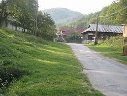
Hačava (1409 Hach, Bognerhey) (German: Wagnerhau; Hungarian: Ájfalucska) is a village and municipality in Košice-okolie District in the Košice Region of eastern Slovakia.
Contents
Map of 044 02 Ha%C4%8Dava, Slovakia
History
First mention of the village is to be found in records dating back to 1409 when it was funded by German settlers driven here by a certain Master Wagner. In the 16th century it belonged to the noble family of Széchy. During that period, it was destroyed by Turks and suffered greatly because of the Polish-Lithuanian War. The place remained almost deserted. In the 18th century some Rusyn colonists contributed to repopulate the village.
Geography
The village lies at an altitude of 660 meters and covers an area of 36.918 km². It has a population of about 225 people. It lies in Hajska-dolina underneath Jeleni Vrch. There is a bike trail available that begins at the town of Moldava-nad-Bodvou, travelling through the nearby village of Haj and ends at Knizna Polona. It is surrounded by a mountainous forest area and a cave is located a few kilometres away.