
South end: US 2 near Gould City | Length 29.3 km | |
 | ||
Existed: c. October 5, 1970 – present Counties | ||
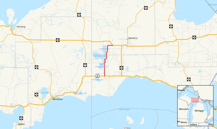
H-33 is a county-designated highway in the Upper Peninsula of the U.S. state of Michigan between Gould City and McMillan that was previously M-135, a former state trunkline highway. The roadway follows Manistique Lakes Road from Gould City at a junction with US Highway 2 (US 2) near Lake Michigan north to M-28 near McMillan. The northern section of the highway is also called County Road 135 (CR 135) in Luce County.
Contents
Map of H-33, Gould City, MI 49838, USA
From 1929 until 1960, the road was part of the state highway system as M-135. The northern end of the highway always contained a section that ran concurrently with M-98, another state highway in the area. For a period in the 1950s, M-135 had a different northern terminus separate from M-98's endpoint. A few years before both highways were removed from the highway system, M-135 was moved to use M-98's terminus with M-28. Since the 1970s, M-135 has been a part of the county-designated highway system and assigned the number H-33, a moniker it has borne since.
Route description
H-33 begins at an intersection with US 2 just west of Gould City. From there the route travels due north through woodlands on Manistique Lakes Road, passing by Mitten and South Manistique lakes. The road crosses Norton and Strom creeks near South Manistique Lake before entering the community of Curtis. In that town, H-33 intersects the eastern end of H-42. North of Curtis, H-33 passes Manistique Lake as the road crosses the Mackinac–Luce county line. North of the line, H-33 has also been designated CR 135 by the Luce County Road Commission.
Continuing north, the roadway enters the community of Helmer where it meets a junction with the eastern terminus of the eastern H-44 (CR 98, Ten Curves Road) near North Manistique Lake. The roadway also crosses Locke Creek, which flows into that lake. After H-33 leaves Helmer, it continues northward to a junction with North Road Lake Road (CR 438) and Sampsell Road (CR 417). Manistique Lakes Road turns to the east, replacing North Round Lake Road, and H-33 follows suit. The road continues to a junction with M-28 just south of McMillan near East Lake. There H-33 terminates near farms and several small business.
History
In 1929, M-135 was designated, creating the concurrency along the last several miles of M-98. In late 1949 or early 1950, M-28 was realigned to take an angled route southeasterly out of McMillan. The east–west section of the previous M-28 routing was added to M-98 while the north–south segment was added to M-135. By the middle of 1958, M-135 was shifted to follow M-98, removing the roadway section added to its routing previously; this change made M-98 and M-135 concurrent north of Helmer all the way to M-28 once again. M-135 was removed from the state trunkline system in late 1960 or early 1961, and the designation was decommissioned at that time. The M-135 designation has not been reused since. The routing was then assigned as County Road H-33 after October 5, 1970, The road has retained that designation ever since.