
Country Vietnam Time zone UTC + 7 (UTC+7) Local time Saturday 11:54 PM | Capital Ngan Dừa Area 424 km² Province Bac Lieu Province | |
 | ||
Weather 27°C, Wind E at 10 km/h, 86% Humidity | ||
Hồng Dân is a rural district of Bạc Liêu Province in the Mekong Delta region of Vietnam. As of 2003 the district had a population of 95,182 . The district covers an area of 424 km². The district capital lies at Ngan Dừa.
Contents
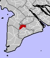
- Map of HE1BB93ng DC3A2n District Bac Lieu Vietnam
- Administrative divisions
- Previous communes
- Economy
- References
Map of H%E1%BB%93ng D%C3%A2n District, Bac Lieu, Vietnam
Administrative divisions
The district is divided administratively into 1 township Ngan Dừa (capital) and communes: Vĩnh Lộc, Lộc Ninh, Ninh Thạnh Lợi, Ninh Hoà, Ninh Quới, Ninh Quới A.
Previous communes
The communes Đông Nam, Đông Phú, Ninh Lợi, Ninh Thuận, Phong Dân, Phong Hiệp, Phong Hoà, Phước Tây, Vĩnh Hiếu, Vĩnh Thành, Vĩnh Tiến and Vĩnh Trung were consolidated as part of administrative reforms.
Economy
Proportion of the sector in GDP by districts as follows: Agriculture 73%, industry and construction 13%, trade and services 14%.
Value of agricultural production increased on average 5-6% annually. Industrial and handicraft industry average from 14-15%. Total income 250 billion 386 million (per capita VND 2,763,000 - equivalent to 184 USD)
The district also has 8,000 ha dedicated to shrimp farming, fish 400 ha, 2,570 ha pineapple, sugar cane 1,022 ha, and 1,505 ha for coconut.
Traditional handicrafts also employ more than 10,000 in knitting, textile making, lace trade, carpentry, etc.