
Discharge 43.7 m³/s Basin area 2,900 km² | Basin size 2,900 km (1,100 sq mi) Length 148 km | |
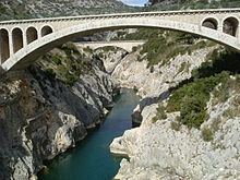 | ||
Bridges Pont du Diable, Hérault, Pont de Saint-Étienne d'Issensac, Gignac Bridge, Roman Bridge | ||
The Hérault ([eʁo]; Occitan: Erau) is a river of southern France. Its length is 148 kilometres (92 mi). Its source is on the slopes of Mont Aigoual in the Cévennes mountains. It reaches the Mediterranean Sea near Agde.
Contents
Map of H%C3%A9rault, France
Towns
The Hérault flows through the following départements and towns:
Navigation
The lower reaches of the Hérault, from Bessan to the sea at Agde, are navigable. The lowest 2.5 kilometres (1.6 mi) are tidal, whilst the next 1 kilometre (0.62 mi) forms part of the Canal du Midi. These two sections of the river are linked to each other, and to the Canal du Midi to the west, by short junction canals and the famous Agde Round Lock.
At the upper end of the section of the Hérault used by the Canal du Midi, the Prades Lock provides access to the Canal du Midi to the east. Above this lock, the river is navigable for a further 4 kilometres (2.5 mi) or so.