
Mountain type Schist
Ridge | Elevation 758 m | |
 | ||
Parent range Fichtelgebirge (Smrčiny) Range Fichtel Mountains (Smrčiny) Similar Lesný, Olověný vrch, Blatenský vrch, Komorní hůrka, Aberg | ||
Rozhledna h j u a e
The Háj u Aše (German: Hainberg bei Asch, 758 m) is the highest elevation in the Bohemian part of the Fichtelgebirge mountains (Smrčiny). It is the local mountain of the town of Aš (Asch) in the Czech Republic.
Contents
- Rozhledna h j u a e
- Map of HC3A1j u AC5A1e 352 01 AC5A1 Czechia
- H j u a e
- LocationEdit
- HistoryEdit
- ViewsEdit
- Paths to the summitEdit
- References
Map of H%C3%A1j u A%C5%A1e, 352 01 A%C5%A1, Czechia
H j u a e
LocationEdit
The Háj rises immediately northeast of the town of Aš in the Bohemian Vogtland. Other settlements in the area Dolní Paseky (Niederreuth) and Podhradí (Neuberg) which belong to the borough of Aš. On the summit is a mountain inn with an observation tower.
HistoryEdit
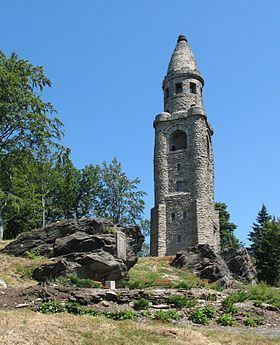
On 19 June 1904 the 34 metre high stone observation tower on the summit was opened. It was designed by the Dresden architect, Wilhelm Kreis. The tower still stands and is one of the three Bismarck towers on the territory of the Czech Republic.
ViewsEdit
From the tower there are good views over the Fichtelgebirge, Elstergebirge and Ore Mountains.