
Population 6,873 (2011 census) | Postcode(s) 2227 Postal code 2227 | |
 | ||
Location 27 km (17 mi) south of Sydney CBD | ||
The suburb of Gymea Bay is located in southern Sydney, in the state of New South Wales, Australia. Gymea Bay is 27 kilometres (17 mi) south of the Sydney central business district, in the local government area of the Sutherland Shire. The postcode is 2227, which it shares with the adjacent suburb of Gymea.
Contents
- Map of Gymea Bay NSW 2227 Australia
- History
- Population
- Commercial area
- Schools
- Recreation
- Coonong Creek Bushland Reserve
- References
Map of Gymea Bay NSW 2227, Australia
The suburb of Gymea Bay takes its name from the small bay of the same name on the north side of the Port Hacking estuary (also known as the Port Hacking River). The suburb included only the area of the single peninsula between Gymea Bay and the North West Arm of the Port Hacking River and bounded by Coonong Creek on the north and, on the west, by an unnamed creek flowing south of Gymea Bay Road between Barraran Street and Coonong Road.
In 2008, the NSW Geographical Names Board suggested a much enlarged area for the suburb of Gymea Bay, taking in much of former Gymea and even part of the suburb of Miranda, in which the suburb's extremities are defined by Forest Road on the northeast, Avenel Road on the north, Dents Creek on the west, and the waters of North West Arm and the bay itself to the south. These boundaries remain contentious.
The area is characterised by large amounts of verdant bushland. However, since the 1980s, increased subdivision with smaller lots, larger houses and increased motor vehicle ownership has decreased the number of large trees and since the 1990s, the invasions of feral deer from the Royal National Park have begun to negatively affect the ground cover underneath the tree canopy.
History
The bay, the locality, suburb and the adjacent suburb of Gymea, were named after the Gymea Lily Doryanthes excelsa, a tall perennial (up to 6m) that is prevalent in the area. The plant was called "Gymea" by the local Eora people and became the inspiration for the suburb's name, by government surveyor W.A.B. Geaves in 1855. The Gymea Lily has been adopted as a symbol of the area and features on the crest of many local organisations. Development in the area has eradicated most of these lilies but some can still be found, a few kilometres south in the Royal National Park.
The settlement at Gymea Bay grew around the transport access to the Port Hacking River. With the opening of a railway line from Sydney to Sutherland in 1885, coaches could reach Gymea Bay as the closest point on the Port Hacking River by relatively easy grades. Gymea Bay Road originally led all the way to the shore of Gymea Bay where a wharf and boat shed developed and mail and supplies were taken by boat to houses along the Port Hacking River. Gymea Bay developed from a rural area into a recreation and holiday area with fishing shacks and holiday homes. Boats could be hired at the boatshed. By the 1920s a coach depot was built on what is now the reserve and playground at the intersection of Gymea Bay Road and Sylvania Road South (now Casuarina Road) and a general store, Post Office and a community hall (on Sylvania Road, now 26 Greyum Place) all existed. Another general store, churches, a joinery factory, a playground, tennis courts and later a butcher's shop all developed at or near this intersection. A progress association, now Gymea Bay Community Association, was formed. Gymea Bay Public School was opened at what was then the fringe of the suburb, on the site of the current Old School Park. Gymea Bay Baths were built and Gymea Bay Amateur Swimming Club developed as did a short lived sailing club and club boatshed on the shore opposite the baths. Kemp's Cosy Cabins and Caravan Park operated on the south of the peninsula from Ellesmere Road to the North West Arm of the Port Hacking River. A petrol service station opened at 237 Gymea Bay Road opposite Vernon Avenue and a much larger bus depot was built at 227 Gymea Bay Road.
Aerial photographs of the 1930 and 1955 show the original Gymea Bay settlement.
The Gymea Bay community lost much of its identity when the public school was moved to a new site further up Gymea Bay Road to a new subdivision, beyond the boundary of Gymea Bay. The Council moved the community hall from Gymea Bay near the intersection of Gymea Bay Road and Sylvania Road (now 26 Greygum Place) to the new reserve and oval, beyond the boundary of Gymea Bay. By the 1970s, St. Barnabus, Church of England, was the only remaining church, the joinery factory closed, and the shops began to decline, Wagner's general stores at Gymea Bay Road closed, Kemp's Cosy Cabins and Caravan Park closed and was subdivided for the housing of Flat Rock Road, Miss Cook's general store built new premises then continued under new ownership, later the Post Office and butchers shop closed, the bus depot ceased operation and eventually the service station closed. The boatshed closed when the Council refused to allow it to operate a cafe to support it financially.
Population
At the 2011 census, there were 6,873 residents in Gymea Bay. The majority of people were born in Australia and the most common ancestries were Australian, English and Irish. The median household weekly income of $2,204 was substantially higher than the national figure of $1,234.
Commercial area
The suburb of Gymea Bay is mostly residential, with a small group of shops located in Casuarina Road near the intersection of Gymea Bay Road. The suburb's needs are principally served by shops in neighbouring suburbs, especially Gymea and Miranda.
Schools
Gymea Bay Public School was once located within Gymea Bay but was relocated in Gymea, just outside Gymea Bay. Gymea Bay Public School, is now the largest primary school (by number of students) in the Sutherland Shire.
Recreation
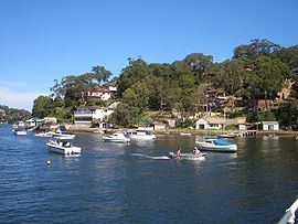
Gymea Bay is home to the heritage-listed Gymea Bay Baths, at the shore of Gymea Bay Baths Reserve at the intersection of Gymea Bay Road and Ellesmere Road. Gymea Bay Amateur Swimming Club has been using the baths for over 40 years. The bay and Port Hacking estuary are used extensively for watersports such as wakeboarding and water skiing.
Coonong Creek Bushland Reserve
Coonong Creek Bushland Reserve in Gymea Bay is an award winning remnant bushland area maintained by Sutherland Shire Council and volunteers. Its walking tracks link with the Old School Park and Gymea Bay Baths Reserve.