
Type Bay Frozen never Federal division Division of Cook | Primary inflows Postal code 2227 | |
 | ||
Location | ||
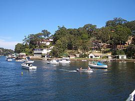
The Gymea Bay is a bay on the upper estuarine Port Hacking River, fed by the Coonong Creek in southern Sydney, in the state of New South Wales, Australia
Contents
- Map of Gymea Bay NSW 2227 Australia
- Payne pacific estate agents lifestyle video gymea and gymea bay payne pacific estate agents
- Location and features
- Recreation
- References
Map of Gymea Bay NSW 2227, Australia
Payne pacific estate agents lifestyle video gymea and gymea bay payne pacific estate agents
Location and features
The bay, the locality, suburb of Gymea Bay and the adjacent suburb of Gymea, were named after the Gymea Lily Doryanthes excelsa, a tall perennial (up to 6m) that is prevalent in the area. The plant was called "Gymea" by the local Eora people and became the inspiration for the suburb's name, by government surveyor W.A.B. Geaves in 1855. The Gymea Lily has been adopted as a symbol of the area and features on the crest of many local organisations. Development in the area has eradicated most of these lilies but some can still be found, a few kilometres south in the Royal National Park.
Recreation
Gymea Bay is home to the heritage-listed Gymea Bay Baths, at the shore of Gymea Bay Baths Reserve at the intersection of Gymea Bay Road and Ellesmere Road. Gymea Bay Amateur Swimming Club has been using the baths for over 40 years. The bay and Port Hacking estuary are used extensively for watersports such as wakeboarding and water skiing.