
Architectural style Multiple Designated NHLD January 20, 1999 Added to NRHP 13 June 1974 | Architect Multiple NRHP Reference # 74001664 Area 6.002 km² | |
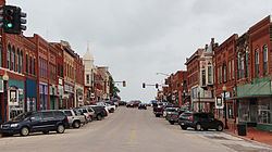 | ||
Guthrie Historic District (GHD) is a historic district in Guthrie, Oklahoma, US. It represents the commercial core of the city. According to its National Historic Landmark Nomination it is roughly bounded by Oklahoma Avenue on the north, Broad Street on the east, Harrison Avenue on the south, and the railroad tracks on the west; it also includes 301 W. Harrison Avenue. The National Historic Landmarks Program on-line document describes the boundaries as "14th Street, College Avenue, Pine Street and Lincoln Avenue. One building, the Logan County Courthouse, is at 301 E. Harrison Avenue, outside the main boundaries of the GHD," This article relies on the former source, which is more detailed. According to the 1998 nomination, the proposed district covered 31 acres (13 ha). The nomination included 112 resources, classed as 69 contributing buildings, 38 non-contributing buildings, 1 non-contributing structure and 3 noncontributing objects. It was declared a National Historic Landmark in 1999.
Contents
Period of significance
The period of significance is defined as 1889 to 1910, when most of the contributing buildings were erected. The most notable architect at the time was Joseph Pierre Foucart, who designed many of the buildings in the table below. The city of Guthrie was founded in 1889 and promptly became the capital of Oklahoma Territory. When Oklahoma became a state on November 16, 1907, Guthrie became the first state capital, until 1910, when the seat of government moved to Oklahoma City. Guthrie declined in commercial importance and changed little for many years. The GHD was assessed to have a high degree of historic integrity.
Architectural styles
Building classifications
As part of the application process, all of the significant buildings within the proposed district boundaries were labeled as either "Contributing" or "non-contributing". Buildings in the former category had to meet the following criteria:
The table presented here identifies the buildings contained by the GHD, as defined in the NRHP application. Data are largely derived from text descriptions in the application.