
Municipality Gurjaani Website gurjaani.ge Local time Sunday 6:36 AM | Town 1934 Elevation 415 m Population 8,024 (2014) | |
 | ||
Weather 6°C, Wind W at 10 km/h, 91% Humidity | ||
Gurjaani (Georgian: გურჯაანი) is a town in Kakheti, a region in eastern Georgia, and the seat of the Gurjaani Municipality. It is located in the Alazani River Plain, at an elevation of 415 m above sea level.
Contents
Map of Gurjaani, Georgia
Gurjaani is first recorded as a village in a historical document of the early 16th century. It acquired the status of a town in Soviet Georgia in 1934. As of the 2014 census, Gurjaani had the population of 8,024. The town is the center of the largest wine-making region of Georgia.
Background
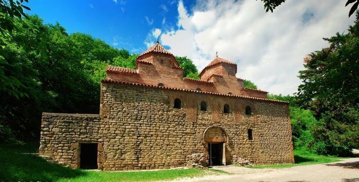
Gurjaani is situated in the fertile Alazani Plain, at 415 m above sea level, and 110 km east of Georgia's capital of Tbilisi. It is the center of an important region of viticulture and wine-making. Important landmarks of the town are Akhtala, a historic spa, locally known for its mud bathes, and the early medieval Gurjaani Kvelatsminda Church, the only example of a two-domed design in Georgia. There are also several museums, the largest of which is the Gurjaani Museum of Local Lore and History.
History
The territory of Gurjaani has not been systematically studied archaeologically. Occasional and incidental finds, such as burials, pottery, and Byzantine coins, suggest it was a home to an established settlement in the early Middle Ages. Gurjaani is first documented as a village in a charter issued in the name of King Alexander I of Kakheti (r. 1476–1511), granting the locale an exemption from taxation. In historical documents Gurjaani is frequently mentioned together with the toponym of Kakhtubani, which is now one of the town's neighborhoods and home to the Kvelatsminda Church. Gurjaani was in possession of the Andronikashvili noble family. As a result of a series of marauding inroads from the mountains of neighboring Dagestan, Gurjaani had been virtually depopulated by the 1770s.
Gurjaani rose to a larger settlement when a railway was constructed in Kakheti in 1915. It became a center of the newly created homonymous district—a predecessor of the present-day municipality—in 1930 and became a town in 1934. During Soviet-era industrialization, Gurjaani had wine-making, canning, distilling, brick-making, and mechanical repair plants.
The post-Soviet political and economic crisis took its toll on Gurjaani in the 1990s. The population dwindled, industry declined, and violent crime was on the rise. An armed group with ties to the Mkhedrioni paramilitary organization was implicated in several high-profile murders. The Mkhedrioni itself was in de facto control of the Gurjaani district from 1992 to 1995. Despite political and relative economic stability achieved in the 2000s, Gurjaani still lacks some elements of proper urban infrastructure and services.
Population
As of the 2014 national census, Gurjaani had the population of 8,024, with an ethnic Georgian majority.