
OS grid SD390885 Elevation 321 m | Topo map OS Landranger 96 Prominence 217 m | |
 | ||
Similar Top o'Selside, Whitfell, Claife Heights, Watch Hill, Muncaster Fell | ||
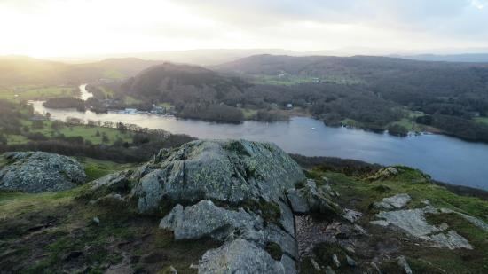
Gummer's How is a hill in the southern part of the Lake District, on the eastern shore of Windermere, near its southern end. How, derived from the Old Norse word haugr, is a common local term for a hill or mound.
Map of Gummer's How, Ulverston, UK
Although a relatively small hill (321 metres above sea level) by the standards of the Lake District, it is the highest of the foothills in the area, and commands excellent views, particularly along Windermere (the summit looks out over the magnificent Town Head House estate towards the lake), but also across to the Coniston fells and the central fells, as well as the broad panorama of Morecambe Bay. There is an OS trig point on the summit.
The walk to the summit is usually from the road at Astley's Plantation car park, itself at over 200 metres above sea level, and only 700 metres from the summit. Although short and easy by most standards, and popular with families, it has many of the characteristics of a walk in the higher Lakeland fells, with some (short) steep slopes, rocks to negotiate, and rowan, bracken and heather. The lower slopes are forested, but the upper portion is moorland.
Gummer's How is the subject of a chapter of Wainwright's book The Outlying Fells of Lakeland. He describes it as "an old man's mountain", and says of it: "And when ancient legs can no longer climb it know ye that the sad day has come to hung up the boots for ever and take to slippers".