
Location Far North | River sources Ob River River source Ob River | |
 | ||
The Gulf of Ob (also known as Ob Bay) (Russian: О́бская губа́, Obskaya guba) is a bay of the Arctic Ocean, located in Northern Russia at the mouth of the Ob River. It is the world's longest estuary.
Contents
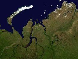
Map of Gulf of Ob, Russia
Geography
The mouth of the Gulf of Ob is in the Kara Sea between the Gydan and Yamal peninsulas. It is about 1,000 km (600 mi) long and varies in width from about 50 to 80 km (30–50 mi), and generally runs north and south. The gulf is relatively shallow, with an average depth from 10 to 12 metres (33 to 39 ft), which restricts heavy sea transport. The Taz Estuary is an eastern side-branch formed by the Taz River.
There are several islands near the mouth of the Ob, at the beginning of the estuary, such as Khaley Island. All these islands are close to the shore and they are generally flat and low-lying. They are protected wetlands under Ramsar. Further north, except for a few islands located close to the shore, such as Khalevigo and Nyavigo, the Gulf of Ob is free of islands until it meets the Kara Sea.
Beluga whales seasonally migrate to the Gulf of Ob.
Hydrocarbons
Very large gas and oil deposits have been discovered in this region. Oil and gas from the wells are sent South via pipeline and rail transport. The Yamburg gas field is the world's third largest natural gas field, and is located between the southern portion of the gulf and the Taz Estuary to the east. A new port is being developed at Sabetta, on the west bank of the gulf.