
Country India Region North Karnataka Headquarters Kalaburagi Area 10,951 km² | State Karnataka Division Kalaburagi Division Time zone IST (UTC+5:30) Elevation 454 m | |
 | ||
Weather 24°C, Wind NW at 6 km/h, 26% Humidity Points of interest Gulbarga Fort, Sharana Basaveshwara Temple, SRI RAM MANDIR GULBARGA, Buddha Vihar, Haft Gumbad | ||
namma gulbarga documentary on gulbarga district the orchid mall
Gulbarga district officially known as Kalaburagi district is one of the 30 districts of Karnataka state in southern India. Kalaburagi city is the administrative headquarters of the district.
Contents
- namma gulbarga documentary on gulbarga district the orchid mall
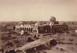
- Map of Gulbarga Karnataka
- History
- Cities and towns in Gulbarga District
- Economy
- Historical places
- Worlds Longest Cannon at Bahmani Fort
- Religious places
- Geography
- Divisions
- Demographics
- Cuisine
- Transport
- Politics
- Education
- References
Map of Gulbarga, Karnataka
This district is situated in northern Karnataka between 76°.04' and 77°.42 east longitude, and 17°.12' and 17°.46' north latitude, covering an area of 10,951 km². This district is bounded on the west by Bijapur district and Solapur district of Maharashtra state, on the north by Bidar district and Osmanabad district of Maharashtra state, on the south by Yadgir district, and on the east by Ranga Reddy district and Medak district of Telangana state.
History
The city of Kalburgi was founded in the 10-11th century (no evidence and reference are available) . Thereafter, during 13th century, the Bahmani Sultans chose the city as their capital they called Gulbarga. Gulbarga literally means garden of roses. However, the history of the region dates back to the 6th Century when the Rashtrakutas gained control over the area, but the Chalukyas regained their domain and reigned for over two hundred years. Around the close of the 12th century, the Yadavas of Devagiri and the Hoysalas of Halebidu took control of the district. The present Gulbarga District and Raichur District formed part of their domain.
The northern Deccan, including the district of Gulbarga, passed under control of the Muslim Sultanate of Delhi. The revolt of the Muslim officers appointed from Delhi resulted in founding of the Bahmani Sultanate in 1347 by Alauddin Hasan Bahman Shah, who chose Gulbarga (Ahasnabad during this period) to be his capital.
From 1724 to 1948 the territory occupied by the present-day Gulbarga district was part of Hyderabad state ruled by the famous and one of the richest kings in the world, the Nizam. They developed roads, railways, educational system and established airport and many more. It was integrated into India in September 1948.
Cities and towns in Gulbarga District
Economy
In 2006 the Ministry of Panchayati Raj named Gulbarga one of the country's 250 most backward districts (out of a total of 640). It is one of the five districts in Karnataka currently receiving funds from the Backward Regions Grant Fund Programme (BRGF).
Historical places
The walls and ceiling of the tomb of Sultan Firuz Shah Bahmani can be appreciated which, although in monotone, represents faithfully the various creepers and floral patterns, the numerous geometric devices, and several calligraphic styles. The most notable building, however, of this period is Jama Masjid of Gulbarga fort, built by Persian architect named Rafi in 1367 during the reign of Muhammad Shah Bahmani I.
The glory of the towns in north Karnataka really waned with the decline of Bahmani dynasty, although Barid Shahi and Adil Shahi kings kept up its beauty during their chequered rule. Royal patronage played an important role in the making of Islamic art, as it has in the arts of other culture. From fourteenth century onwards, especially in the eastern lands, the books of art provide the best documentation of the courtly patronage. Today, the finest arts are found in India, Turkey, Iran, Syria, Pakistan, Egypt and Morocco, where the legacy of Islamic arts remain live and strong.
World’s Longest Cannon at Bahmani Fort
The Bahmani Sultanate was a first independent Islamic state of the Deccan in South India and one of the great medieval Indian kingdoms. During the 191 years (1347-1538 A.D.) of Bahmani reign ruled with Gulbarga (Ahasnabad) and Bidar as their capital It was a great discovery for National award winner artist and photographer Mohammed Ayazuddin Patel, Indo-Islamic Art of North Karnataka researcher Dr Rehaman Patel and coin collector Mohammed Ismail that have found the World’s longest canon in our own city.
It is exciting news for Gulbarga and Hyderabad Karnataka region people that the longest canon is located in Gulbarga fort installed during the reign of Bahmani Empire in 14th century made by Turkish. It is made up of alloy (Panch dhatu).
It is the Bara Gazi toph (canon) which measures about 29 feet in length. Circumference is 7.6 feet, diameter 2 feet and thickness is 7 inch.
But the canon which claims to be the largest one in the world is just 23 feet long. This canon is located Koulas fort in Nizamabad district, Andhara Pradesh. The Asaf Jah-I (first Nizam) granted the Koulas fort to Rajput king Raja Kunwar Gopal Singh Gaur in 1724 AD for his bravery in the battle of Balapur and Shakkar Kheda.
The Archaeological Survey of India and State Archaeology should take immediate step to protect the Gulbarga fort canon and it should be included in world record list. Fencing should be done around the canon for its safety. The canon is filled with mud and small stones which should be cleaned. Also, a sign board containing the details about the size of canon mentioning it as ‘the longest canon in the world is required.
Religious places
14th Century Hazrat Khwaja Bande Nawaz : Dargah of 14th Century is another major attraction for devotees irrespective of caste and creed, dedicated to the famous Sufi saint who preached understanding, tolerance and harmony. Thus Gulbarga is known to be a hub of Hindu-Muslim harmony. This complex is to be considered the largest in India. Several tombs interior is decorated in Persian style paintings also known as Deccani art. Natural pigments are used to paint the walls and inner domes. The artists were invited from Iran in 14th Century. Its a kind and largest mural paintings in India.
Thousands of pilgrims visit Gulbarga during the annual festivals i.e. Urs (Holy Gathering) of Khwaja Bande Nawaz. The festival are well attended by people from surrounding places of all faiths. Hazrat Mohammad Badshah Qadri Darga (Wadi)was a famous Sufi Saint of the region.
19th Century Appana Gudi Sharnbasveshwara Temple : Sharnbasaveshwara Temple also known as Appana Gudi is one of the Religious place to visit, dedicated to an eminent Hindu religious teacher and philosopher, Shri Sharnbasaveshwara, a Lingayat saint of 18th Century known for his Dasoha (Giving is earning) and Kayaka - an advancement of the Karma doctrine - "You have the right to perform the work assigned to you. You have no rights to 'demand' the fruits of your labor" philosophy.
"20th Century Siddharth Buddha Vihar" : Siddharth Vihar Trust that has built the inspiring Buddha Vihar in Gulbarga. The Buddhist Vihar was inaugurated by the President of India on January 7, 2009. The idol of Buddha was consecrated by The Dalai Lama on January 19, 2009.
"Gangapur (Gandharwapuram)" : Gandharwapuram, on the bank of Bhima river, is where Sri Narasimha Saraswati Guru Maharaj, the second incarnation of Datta tattva resided for almost 25 years. It has been a center of spiritual enlightenment for all religions during that period and as is the case with all Spiritual Masters, the work of spiritual enlightenment continues to this day in this great place. The Math where Sri Guru left his Nirguna Padukas before he ended his work in physical form, is the center of this town. Some places of interest to spiritual seekers are the Bhima-Amaraja Sangam, the Ashta Teerthas along the Bhima river, Kalleswara Temple, Sangameswara Temple etc. This is about 40 km from Gulbarga.
Geography
Gulbarga is situated in Deccan Plateau located at 17.33°N 76.83°E / 17.33; 76.83 and the general elevation ranges from 300 to 750 meters above mean sea level. Two main rivers, Krishna and Bhima, flow in the district. Black soil is predominant soil type in the district. The district has a large number of tanks which, in addition to the rivers, irrigate the land. The Upper Krishna Project is major irrigation venture in the district. Bajra, toor, sugarcane, groundnut, sunflower, sesame, castor bean, black gram, jowar, wheat, cotton, ragi, Bengal gram, and linseed are grown in this district.
The weather in Gulbarga consists of 3 main seasons. The summer which spans from late February to mid June. It is followed by the south west monsoon which spans from the late June to late September heavy rainfall may go up to 750mm. It is then followed by dry winter weather until mid January. Barring the hot summer months, the salubrious weather of Gulbarga makes a visit to this historical city a pleasant one.
Temperatures during the different seasons are:
Divisions
Gulbarga district presently comprises the following 7 talukas after the separation of Yadgir district from it.
- Gulbarga
- Aland
- Afzalpur
- Jevargi
- Sedam
- Chitapur
- Chincholi
Demographics
According to the 2011 census Gulbarga district has a population of 2,564,892, roughly equal to the nation of Kuwait or the US state of Nevada. This gives it a ranking of 162nd in India (out of a total of 640). The district has a population density of 233 inhabitants per square kilometre (600/sq mi) . Its population growth rate over the decade 2001-2011 was 17.94%. Gulbarga has a sex ratio of 962 females for every 1000 males, and a literacy rate of 65.65%.
Kannada and Urdu are the prominent languages spoken in this district. Hinduism and Islam are principle religions followed in this district.
Cuisine
Tahari : Tahari is similar to pulao and is one of the famous dish in Gulbarga. Tahari is prepared by adding the meat to the rice, as opposed to the traditional Biryani where the rice is added to the meat. It is very tasty and similar to Biryani in taste and texture.
Jolada Rotti: Jolada Rotti or Jawar ki rotti is the staple diet of the region. It is prepared from jowar flour. Jolada Rotti is served with a traditional curry (which vary in ingredients and types) and spiced peanut powder (called "Shenga Chutney Pudi"). Generally, the food in Gulbarga is believed to be very spicy when compared with the rest of the state.
Bele Hoorana Holige : This is a sweet which is a specialty in the place and prepared on all festivals. It is kind of stuffed pancake. Chickpeas and Jaggery are ground and stuffed into wheat flour and then cooked. This is served with Mango pulp as a side dish.
Transport
Gulbarga city is well connected by road and rail from Bangalore,Hyderabad, Mumbai & other major cities.
Local Transport : Taxis and auto rickshaws are available for getting around the city at fairly reasonable rates. NEKRTC city buses also ply within the city and also go to the nearby towns and villages.
Long Distance Bus Routes : KSRTC runs the bus service to other cities and villages. Also there are plenty of private bus services. The Bidar-Srirangapatna state highway made travel easy to Bangalore, and neighboring states of Maharashtra, Goa. There are many private services running Volvo buses between Bangalore-Gulbarga,Mumbai-Gulbarga.
Railways : Gulbarga is well served by major rail lines and is connected to all major parts of India such as Mumbai, Delhi, Bangalore, Chennai, Ahmadabad, Rajkot, Agra, Bhopal, Coimbatore, Kanyakumari, Trivandrum, Bhubneshwar etc. A new Railway Division at Gulbarga is expected to become operational shortly.
AirPort : Nearest airport is Hyderabad International Airport 220 km from City. A new airport in Gulburga is under construction.
Politics
Gulbarga is home for two ex-chief ministers of Karnataka, namely Late Veerendra Patil (1968–1971, 1988–1990) and N. Dharam Singh(2004–2006) belonging to the Congress party.
The current member of Parliament from Gulbarga is Mr Mallikarjun Kharge. He was honourable Minister for Railways, Republic of India.
The members of the State Legislative Assembly are Mr Qamar ul Islam (Gulbarga North), Mr Dattatreya Patila Revoora (Gulbarga South) and Mr G Ramakrishna (Gulbarga Rural).
Education
Gulbarga has two Universities and is the house of only Central University of Karnataka, which is located in Kadaganchi. The other university is Gulbarga University. Gulbarga also has three engineering Colleges, a Govt Medical College, ESIC Medical College, a Private Medical college, a Fine Arts college, several pharmacy colleges and degree colleges. Gulbarga is fast emerging as an educational hub of North Karnataka.