
 | ||
Guanahani is an island in the Bahamas that was the first land in the New World sighted and visited by Christopher Columbus' first voyage, on October 12, 1492. It is not known precisely which island it was. Guanahani is the native Taíno name; Columbus called it San Salvador.
Contents
1492 llegada y encuentro en guanahani
Trans-Atlantic track
The first way to locate Guanahani is to follow the distances and directions Columbus gave in his log. This procedure is difficult because of the uncertainties in knowing the length of Columbus's league, the speed and direction of ocean currents, and the exact direction his magnetic compass would have pointed in 1492.
John McElroy was one of the first to attempt this in 1941, using a speculative magnetic chart for the year 1500 and currents from pilot charts. His vast overrun in distance was corrected by a fudge factor, leaving his endpoint in the vicinity of Watlings Island. This result was substantially confirmed by Doug Peck's sailing voyage of 1991.
In 1986, Luis Marden of the National Geographic Society applied currents to the first half of the voyage (but not the second half) and determined Samana Cay as the most probable landfall.
In 1992, Goldsmith and Richardson used vector average currents (rather than prevailing currents) along with an updated magnetic field, and found a track that ended in the vicinity of Grand Turk Island.
In 2004, Keith Pickering applied magnetic declinations from a more modern source and found a track that ended in the vicinity of the Plana Cays.
Light seen on the evening preceding the discovery
At 10 p.m. on October 11, Columbus saw a light "like a small wax candle that rose and lifted up". He pointed it out to other people on board, some of whom were able to see the light, while others did not. The actual landfall was about 35 miles from the location Columbus saw the light, so if taken that the light was from a ground-based source, then it could not have been from Guanahani, but must have been from another island farther east. For the Plana Cays theory, the light would have been on Mayaguana. For Conception, it could have been on Cat Island, Watling/San Salvador or Rum Cay. For Caicos it could have been on Grand Turk. For Cat Island it could have been Watling/San Salvador and for Lignum Vitae Cay it could have been Eleuthera Island. The Watlings, Grand Turk, and Egg Island theories have no ready explanation.
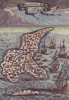
Description of Guanahani
Columbus calls the island "very flat and with very green trees", which is true for all of the proposed islands. His next statement is more problematic. He says Guanahani has "muchas aguas y una laguna en medio muy grande" – many waters and a laguna in the middle (or "in between") very big. The word laguna creates many problems. It is uncertain whether it means lagoon or pond. In any case, most of the proposed islands have either a lagoon or pond; only East Caicos lacks one.
On October 14, Columbus made a boat trip to "the other part, which was the eastern part" of Guanahani. Therefore, he went the length of the island in a North-northeast direction. This is possible only at Plana Cays, Conception and Egg, and to a very minor extent at Samana Cay. Columbus noticed a reef that completely surrounded the island. All proposed islands have a reef, but the ones on Cat and Watlings do not completely surround the island. Between the reef and the island was a harbor "large enough to store all ships of Christendom." This could easily have been an exaggeration. The harbor on Egg is definitely too small, although it is fairly appropriate for the impressive harbor at the neighboring islet of Royal Island, which could have been considered part of the same larger island he named "San Salvador" (the other "part, which is the eastern part"). Columbus went on land and saw "a piece of land, that looked like an island, but actually wasn't one." This is difficult to track, because it may have become a real island in the past 500 years.
Island or islands
One question in dispute is whether Guanahani was one island or more than one. Evidence is said to be inconclusive. Columbus never says specifically that Guanahani consisted of more than one island, something which is surely worth noting. But he does say that Guanahani had "another part, which is the eastern part"; and to explore that eastern part, he used a boat rather than walking, which may be significant.
On reproductions of the map by Juan de la Cosa, who was with Columbus, Guanahani looks to some researchers like a string of small islands.
Inter-island track
Besides the transatlantic track, the other important method for determining the location of Guanahani is the inter-island track, which can be traced either forward (from Guanahani to Cuba) or backward (from Cuba to Guanahani). Given the numerous descriptions of courses, distances, and directions in the log, this method seems more likely to pinpoint the location, and has been by far the most frequently used method of historians.
It was common practice among 20th-century historians to refer to the various Bahamian islands visited by Columbus by Roman numerals to avoid confusion: Island I being Guanahani, Island II being the second island visited by Columbus (which he named Santa María de la Concepción); followed by Island III (named Fernandina by Columbus) and Island IV (called Samoete by the Indians and renamed Isabela by Columbus).
Following these four islands, Columbus next visited a string of seven or more islands in a line running north-south (which historians generally agree must be the modern Ragged Island Range) before landing on the north coast of Cuba. A successful inter-island track must therefore navigate from Guanahani to the Ragged Islands in a way that fits the descriptions of the log without serious infidelity. Strictly speaking this is impossible, as there are a few places where the log seems to contradict itself.
Island II
Leaving Guanahani late on October 14, Columbus said "I saw so many islands I did not know how to decide which one I would go to first". Aiming for the largest, he estimated its distance by eye at five leagues, while other islands were both nearer and farther than that.
He arrived at Island II around noon, delayed by a contrary marea (usually translated as "tide", although "breeze" is possible), re-estimating the distance as seven leagues rather than five. Island II had a coastline facing Guanahani that ran north-south for five leagues, and another coastline ("which I followed", says Columbus) that ran east-west for more than ten leagues.
At this point comes a contentious passage in the log: "And since from this island I saw another larger one to the west, I spread sail to go forward all that day until night, because [otherwise] I would not have been able to reach the western cape of the island". From this it is unclear whether the "western cape" at which Columbus anchored that night was on the island with the five- and ten-league coastlines, or the larger island to the west; in other words, it is unclear whether Columbus was adjacent to one or two islands on October 15. Those who prefer the two-island interpretation call these Island IIa and Island IIb.
Island III
The log gives two descriptions of the sail from Island II to Island III on October 16: in the first version, Columbus leaves at 10 AM and sails nine leagues east-west to reach Island III; in the second version, Columbus leaves at noon and sails eight leagues "almost east-west" to reach Island III.
Columbus also gives somewhat contradictory information on the size of Island III, saying at first (before actually exploring the island) that it "may well be" more than 28 leagues long; but later saying only that "I saw quite 20 leagues of it but it did not end there."
But Columbus does give quite detailed information on the coastline of Island III, more so than any other island he visited. On the evening of October 16, he arrived at a cape where the coastlines ran NNW and SSW (though some scholars see a possible transcription error here). The following morning (October 17) he followed the coast NNW, and when he was two leagues distant from the end (or "the cape") of the island, he found a "wonderful harbor" with a small island in its mouth forming two narrow entrances. Going into the harbor with boats, he found it too shallow for use and put the boats ashore for water instead. Leaving the harbor after two hours, he then sailed northwest (rather than the previous NNW) "so far that I viewed all that part of the island as far as the coast that runs east-west".
Thus there are four coastlines described at Island III: from the arrival cape, one coast runs SSW, one runs NNW; following the second coast NNW, Columbus arrived at a harbor; continuing along that coast, the coastline runs NW, and then W. These four coastlines and harbor are an essentially perfect fit with the southern part of Long Island.
Columbus ran into foul weather on the night of October 17–18 and gained sea room to avoid running onto a lee shore. He returned to Island III on the 18th, but the log does not specify where on the island he anchored that night. The following morning, October 19, he split his fleet to search for the island of Samoete that his kidnapped Indian guides had told him about.
Island IV
Leaving his Island III anchorage at dawn, Columbus sent Niña SSE and Santa Maria SE, while Pinta was sent "east and southeast" (contrary to the ESE mentioned in some sources). Thus the ships were able to sweep a large area of ocean in search of the island whose position was only vaguely known. The Santa Maria herself raised the island before 9 AM, and signalling the other ships to rejoin, Columbus reached Island IV before noon, arriving at the northern point. Columbus describes this point as being surrounded by a reef, with a small island nearby.
Columbus's descriptions of Island IV are, at best, confusing. He describes Island IV being "on an east-west course" from Island III (which contradicts his previous description of the fleet's movements in the search), and he also asserts that from the northern point the coast ran west for 12 leagues, to its western cape, Cabo Hermoso. The direction of this coastline running west contradicts both Columbus's own arrival at the island (since he arrived at the north point by sailing east, and did not arrive at Cabo Hermoso first) and his later description of his departure from this northern end of Island IV (as he departed sailing SSW and yet did not run aground).
From Cabo Hermoso, Columbus described a "great bight" to the northeast. Further confusing the issue, Columbus then says that he believes Cabo Hermoso is on a separate island from Samoete. The following morning (October 20), he tried to enter the bight in order to circumnavigate the island. That attempt soon proved futile because it was too shallow, and Columbus reversed course and returned to the northern end, awaiting the arrival of the King which his kidnapped Indian guides had told him about.
After two days of fruitless waiting for the King and another day becalmed, Columbus departed from the northern end of Island IV at midnight on October 24, setting his sights on Cuba, the large island to the south he had been told about. He sailed WSW until dawn on the 24th, then was becalmed again until noon, making scant progress in the afternoon. At some point, he fixed his position at seven leagues southeast of Cape Verde, which he describes as being "in the western part of the southern part" of Island III. From that point, he made two leagues on a doubtful course under a rising wind; then, the morning of October 25, he made five leagues WSW and another 11 leagues west when they sighted the Ragged Islands, which he called the Islas de Arena (Sand Islands) running north-south at a distance of five leagues.