
Listing State high point 14th Topo map USGS Guadalupe Peak Prominence 923 m | Elevation 2,667 m Mountain range Guadalupe Mountains | |
 | ||
Similar El Capitan, Bush Mountain, Hunter Peak, Emory Peak, Wheeler Peak | ||
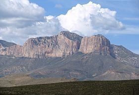
Guadalupe Peak, also known as Signal Peak, is the highest natural point in Texas, with an elevation of 8,751 feet (2,667 m) above sea level. It is located in Guadalupe Mountains National Park, and is part of the Guadalupe Mountains range in southeastern New Mexico and West Texas. The mountain is about 90 miles (140 km) east of El Paso and about 50 miles (80 km) southwest of Carlsbad, New Mexico. The peak rises more than 3,000 feet (910 m) above the arid floor of the Chihuahuan Desert.
Contents
Map of Guadalupe Peak, Texas 79847, USA
Trail and summitEdit
The peak can be climbed by a maintained stony trail (4.25 miles or 6.8 kilometres each way) at any time of the year. The trail is part of the network of hiking trails in the surrounding national park.
A stainless steel pyramid marks the summit. It was erected by American Airlines in 1958 to commemorate the 100th anniversary of the Butterfield Overland Mail, a stagecoach route that passed south of the mountain. One side of the pyramid has the American Airlines logo. The second side displays a U.S. Postal Service tribute to the Pony Express Riders of the Butterfield Stage. The third side displays a compass with the logo of the Boy Scouts of America. A summit register contained in a metal ammunition box is located at the base of the pyramid.