
Country Switzerland Elevation 810 m Population 1,753 (Dec 31, 2008) Area 28.38 km2 | District Gruyere Mayor Syndic | |
Points of interest Moleson, Gruyeres Castle, Lac de Montsalvens | ||
Gruyeres is a town in the district of Gruyere in the canton of Fribourg in Switzerland. Its German name is Greyerz.
Contents
Map of Gruyeres
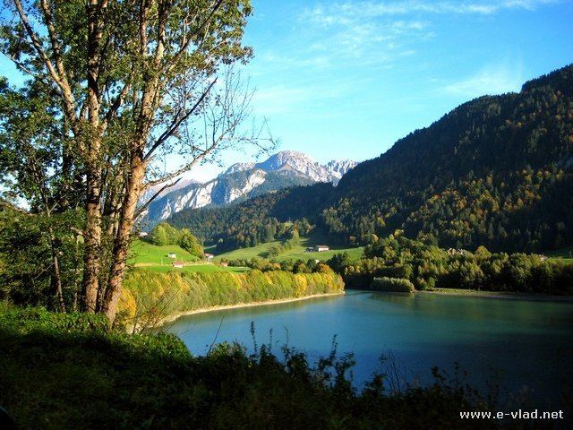
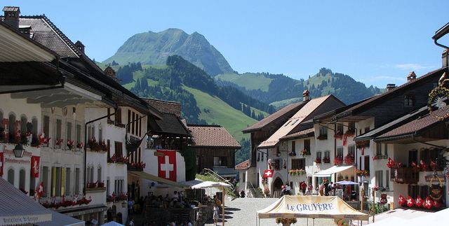
The medieval town is an important tourist location in the upper valley of the Saane river, and gives its name to the well-known Gruyere cheese. The medieval town is located at the top of 82 metre-high hill overlooking the Saane valley and the Lake of Gruyere.
Geography
Gruyeres has an area, as of 2009, of 28.4 square kilometers (11.0 sq mi). Of this area, 11.5 km2 (4.4 sq mi) or 40.5% is used for agricultural purposes, while 14.18 km2 (5.47 sq mi) or 50.0% is forested. Of the rest of the land, 1.55 km2 (0.60 sq mi) or 5.5% is settled (buildings or roads), 0.24 km2 (0.093 sq mi) or 0.8% is either rivers or lakes and 0.92 km2 (0.36 sq mi) or 3.2% is unproductive land.
Of the built up area, housing and buildings made up 2.5% and transportation infrastructure made up 2.1%. Out of the forested land, 46.8% of the total land area is heavily forested and 2.7% is covered with orchards or small clusters of trees. Of the agricultural land, 4.6% is used for growing crops and 12.9% is pastures and 22.9% is used for alpine pastures. All the water in the municipality is flowing water.
Gruyeres is 810 m (2,660 ft) above sea level, 4.5 km (2.8 mi) south-south-east of the district capital Bulle. The historical town is placed on top of an isolated hill north of the alps, in the foothills of mount Moleson. It is also the location where the Saane river (French name: Sarine) leaves the Fribourg alps.
The area of the municipality comprises a section of the Saane valley and of the Fribourg alps. The central part of the area is the plains of Alluvial (690 m [ 2,260 ft ] above sea level) next to the alps, between Gruyeres and Broc, from which the hill of Gruyeres rises to 828 m [ 2,717 ft ] above sea level. From the west, the brook Treme meets the Saane. East of the Saane, the municipality area ends in a small corner, bordered by the ridges of Dent de Broc (1,829 m [ 6,001 ft ] above sea level) in the north and Dent du Chamois (1,830 m [ 6,000 ft ] above sea level) in the south, ending at the valley of Motelon. The two peaks with their saddle between them are a popular subject for photographs of Gruyeres.
Southwest of Gruyeres, the municipality comprises most of the catchment area of the brook Albeuve, which originates on the flanks of mount Moleson. The top of mount Moleson is the highest point of the municipality, reaching 2,002 m (6,568 ft) above sea level. West of the Moleson, the densely wooded right valley side of the Treme and the terrace of La Part Dieu belong to Gruyeres.
The municipality of Gruyeres also comprises the two villages of Epagny (715 m [ 2,346 ft ] above sea level) to the north and Pringy (750 m [ 2,460 ft ] above sea level) to the west of the town hill. Further, the small village Saussivue (710 m [ 2,330 ft ] above sea level) to the south and the holiday settlement Moleson-Village (1,132 m [ 3,714 ft ]above sea level) in the valley of the Albeuve in the foothills of mount Moleson as well as several isolated farms. Neighbour municipalities of Gruyeres are Broc, Charmey, Bas-Intyamon, Haut-Intyamon, Semsales, Vaulruz, Vuadens, Bulle, La Tour-de-Treme and Le Paquier.
History
Graves from the Hallstatt era and La Tene era (325-250 BC) as well as other traces from the Bronze Age were discovered in Epagny. The remains of a Roman era villa from the 2nd-3rd century AD and an Early Middle Ages cemetery were also found nearby. A Roman settlement was probably located on a hill in Gruyeres.
Gruyeres stands in the midst of the Fribourg green pre-Alpine foothills. The castle, towers above the medieval town. Gruerius, the legendary founder of Gruyeres, captured a crane (in French: “grue”) and chose it as his heraldic animal inspiring the name Gruyeres. Despite the importance of the House of Gruyeres its beginnings remain quite mysterious. Gruyeres is first mentioned around 1138-39 as de Grueri. The town developed beneath the castle, which the Count of Gruyere had built on top of the hill, to control the upper Saanen valley. By 1195-96 it became a market town with a central street and city walls. The town developed separately of the castle. In 1397 Count Rudolph IV of Gruyeres confirmed an older town charter that was based on the model of Moudon.
On June 22, 1476, Gruyeres participated in the Battle of Morat against the Charles the Bold, Duke of Burgundy. With the help of the Old Swiss Confederacy, they routed the Burgundian army and captured three capes of the [Order of the Golden Fleece] which belonged to Charles the Bold including one with the emblems of Philip the Good, his father. At the time of the battle he was celebrating the anniversary of the death of his father.
The town church of Gruyeres originally belonged to the parish of Bulle. Count Rudolph III allowed the villages on the left bank of the Saane to built St. Theoduls church. When it was dedicated in 1254, it was the parish church of the new Gruyeres parish. The Counts of Gruyeres were buried under the altar of St. Michael in the church. It was mostly destroyed in 1670 and again in 1856 by fire, which only left the choir and tower undamaged. The renovated church was consecrated in 1860. In addition to the parish church, the Counts had the Chapel of St. John the Baptist in the castle, with two glass windows dating from the late 15th century. The Chapel of St. Moritz in the old hospital was built with the hospital in 1431. The Chapelle du Berceau was built in 1612, following a plague that killed 140.
During the Thirty Years War, nuns from St. Bernard and the Visitation Order fled from Besancon und Dole to settle in Gruyeres. The latter remained in town between 1639 and 1651 and conducted a private school. Starting in the 15th century a primary school opened in town which was open mainly to boys. A secondary school opened in town in the 20th century but it moved in 1973 to Bulle. Gruyeres had a plague house which was first mentioned in 1341. The towns hospital was founded in the mid-15th century and remained in operation until the second half of the 19th century. One side of the hospital building housed the primary school until 1988 and was then renovated into a nursing home. Between 1891 and 1925 the Ingenbohl sisters ran the Deaf and Dumb Institute of Saint-Joseph in Gruyeres. In 1925 it moved to Fribourg.
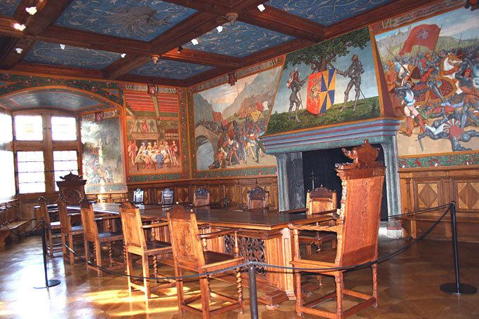
Nineteen counts are accounted for in the period between the 11th and 16th centuries. The last of them, Michel, had been in financial trouble almost all his life only to end in bankruptcy in 1554. His creditors the cantons of Fribourg and Bern shared his earldom between them. From 1555 to 1798 the castle became residence to the bailiffs and then to the prefects sent by Fribourg. In 1849 the castle was put up for sale and sold to the Bovy and Balland families, who stayed at the castle during summer time and restored it with the help of their painter friends. The castle was then bought back by the canton of Fribourg in 1938, made into a museum and opened to the public. Since 1993, a foundation ensures the conservation as well as the highlighting of the building and the collection.