Isolation 103 kilometres (64 mi) Elevation 982 m | Prominence 389 m Parent range Thuringian Forest | |
 | ||
Pronunciation German: [ˈɡʁoːsɐ ˈbeːɐ̯bɛɐ̯k] Similar Schneekopf, Großer Finsterberg, Adlersberg, Kickelhahn, Ruppberg | ||
The Großer Beerberg is a mountain located in the Thuringian Forest, Germany, and the highest point in the state of Thuringia. The nearest town is Suhl.
Map of Gro%C3%9Fer Beerberg, 98559 Gehlberg, Germany
Between the summit of the Beerberg and that of its eastern neighbour, the Schneekopf (978 m), the second highest mountain of Thuringia, is a 60-metre-deep col. To the west is the Sommerbachskopf (941 m).
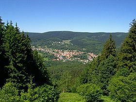
On the summit of Beerberg is one of the few moorlands of the Thuringian Forest. Until the end of the 1980s there was an observation tower on the mountain. A few years ago, a small platform was again established below the summit at Plänckners Aussicht, which offers an outstanding view to the south and southwest.
The section of the Rennsteig long-distance path between Oberhof and Schmücke runs across the mountain.
