
Time zone CET/CEST (UTC+1/+2) Population 1,533 (31 Dec 2008) | Elevation 823 m (2,700 ft) Postal codes 98559 Local time Wednesday 3:42 AM | |
 | ||
Weather -1°C, Wind N at 14 km/h, 89% Humidity Points of interest Fallbachhang Oberhof, Rennsteiggarten Oberhof, Exotarium Oberhof, Rondell Oberhof, Ehemaliges Gästehaus des DDR | ||
Oberhof is a town in the Schmalkalden-Meiningen district of Thuringia, Germany. It is a winter sports center and health resort. It is visited by tenfold as many tourists every year. The town got its official city status in 1985.
Contents
- Map of Oberhof Germany
- History
- International sports events
- Points of interest
- International relations
- References
Map of Oberhof, Germany
History
Oberhof was settled in 1641, and remained a small town until the late 19th century, when the town was connected to the railway line from Erfurt to Ritschenhausen, and skiers and other tourists discovered the place.
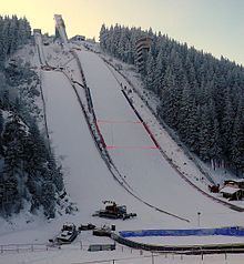
From the early 1900s onwards, Oberhof became a center for winter sports, with luge, nordic skiing, and ski jumping taking place in the town's regularly updated sports facilities. In recent years the town has also seen the construction of lift-equipped alpine skiing slopes and an international competition standard biathlon stadium. Their bobsleigh, luge, and skeleton track has hosted many world and European championships in luge.
In August 2009 the first German ski tunnel opened in Oberhof.
International sports events
Points of interest
International relations
Oberhof, Germany is twinned with: