
Admin. region Unterfranken Elevation 137 m (449 ft) Population 16,353 (31 Dec 2008) | Time zone CET/CEST (UTC+1/+2) Local time Saturday 1:01 AM | |
 | ||
Weather 2°C, Wind SE at 8 km/h, 88% Humidity Points of interest Bachgau‑Museum, Galerie Capriola, Spitzer Turm, Pflaumheimer Rathaus, Kriegsdenkmal 1Weltkrieg | ||
Großostheim (or Grossostheim) is a market community in the Aschaffenburg district in the Regierungsbezirk of Lower Franconia (Unterfranken) in Bavaria, Germany. The inhabitants call themselves Aistmer.
Contents
- Map of 63762 GroC39Fostheim Germany
- Location
- Constituent communities
- Neighbouring communities
- History
- Population development
- Politics
- Coat of arms
- Culture and sightseeing
- Economy agriculture forestry
- Transport
- Education
- Sons and daughters of the town
- Town partnerships
- References
Map of 63762 Gro%C3%9Fostheim, Germany
Location
Großostheim lies on the northeast edge of the Odenwald in the Bavarian Lower Main (Bayerischer Untermain) region.
Constituent communities
Großostheim’s Ortsteile are Großostheim, Pflaumheim, Wenigumstadt and Ringheim.
Neighbouring communities
Clockwise from the north, these are the community of Stockstadt, the district-free town of Aschaffenburg, the community of Niedernberg, the community of Mömlingen (both in Miltenberg district) and the community of Schaafheim (Darmstadt-Dieburg).
Together with Stockstadt am Main and the neighbouring Hessian community of Schaafheim, the market community forms the historic Bachgau region.
History
The market community of Großostheim, as a greater community, is made up of the constituent communities of Großostheim, Ringheim, Pflaumheim and Wenigumstadt. While Ringheim has always been part of Großostheim, the other two places, Pflaumheim and Wenigumstadt, have only been as much since municipal reform on 1 May 1978.
Ostheim, called Großostheim since the 18th century – groß is German for “great” or “big” – had its first documentary mention in a document from the Fulda Abbey dating from sometime between 780 and 799.
Ostheim belonged from the time of its first documentary mention to various lordly domains, before it passed along with the whole Bachgau to the Electorate of Mainz.
The constituent community of Ringheim gets its name from an older village that died out in the early 16th century. The Ringheimer Mühle – a mill, formerly an inn and a farmhouse – seems to be the last piece of property from the old Ringheim. The new Ringheim arose after 1945 on the lands of the former Luftwaffe base, in whose barracks and other buildings Germans driven out of their homelands were housed. Quick growth with industries locating in the new settlement has made of the initially small constituent community a considerable settlement today, which has become a desirable place to live.
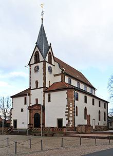
The constituent community of Pflaumheim, despite lying right near the significant centre of Ostheim, had always been an independent community. It did, however, belong ecclesiastically as a branch parish to the parish of St. Peter and Paul in Großostheim. Only in 1923 did Pflaumheim, with its Kirche St. Luzia (church) become an independent parish. In 1994, Pflaumheim’s 1,200-year jubilee was celebrated, as in 794 the Pflaumgau, and in the same era Pflaumheim itself, were named in documents handed down from the Lorsch and Fulda Abbeys.
The constituent community of Wenigumstadt had its first documentary mention in 1229 as villa Omestad minore. The village had, however, surely been settled much earlier, as the many archaeological finds from Wenigumstadt show a human presence from every cultural epoch in the last 7,000 years.
The former (until 1782) Electoral Mainz Vogteiamt (Vogt district) became in 1803 part of Archbishop-Elector of Mainz Karl von Dalberg’s newly formed Electorate of Aschaffenburg, along with which, under the terms of the Treaties of Paris, it passed in 1814 (by this time it had become a department of the Grand Duchy of Frankfurt) to Bavaria.
In the course of administrative reform in Bavaria, the current community came into being with the Gemeindeedikt (“Municipal Edict”) of 1818.
Population development
Within the municipal area lived 12,788 inhabitants in 1970, 13,514 in 1987, 15,913 in 2000 and 16,299 in 2004.
Politics
The mayor is Hans Klug (CSU), last confirmed in office on 2 March 2008 with 69% of the vote.
The income from municipal taxes in 1999 amounted to €9,751,000 (converted) of which net intake from business taxes amounted to €3,180,000.
Coat of arms
The community’s arms might be described thus: Party per fess Or and sable, a buck salient of the second langued gules and couped at the thigh, and three trefoils slipped argent.
Until the 18th century, Großostheim was known simply as Ostheim. It was in 1774 that the name Großostheim first cropped up. The coat of arms, conferred on 17 January 1911 by Prince Regent Luitpold and borne ever since, is a combination of the 17th-century community seal, which is no longer on hand, and a smaller version of the arms borne by the family Schad, whose members called themselves Schad von Ostheim. The family died out in 1581, after having lived for centuries in the Bachgau, to whose tithing district the community of Ostheim then belonged. The cloverleaves below the parting was a popular, old local symbol for agriculture. They are taken from the lost Großostheim community seal and refer to how, in the course of time, clover growing displaced winegrowing.
Culture and sightseeing
Economy, agriculture, forestry
According to official statistics, there were 85 workers on the social welfare contribution rolls working in agriculture and forestry in 1998. In producing businesses this was 2,427, and in trade and transport 1,067. In other areas, 910 workers on the social welfare contribution rolls are employed, and 5,627 such workers work from home. There were 9 processing businesses. Fourteen businesses are in construction, and furthermore, in 1999, there were 84 agricultural operations with a working area of 2 656 ha, of which 2 428 ha was cropland and 193 ha was meadowland. There are a brewery and several winegrowing operations here.
The best known firm in the community was the European head office of Nintendo before its closure and relocation to Frankfurt in 2015. Also, the meat processing business Salomon Foodworld is resident here.
Transport
Großostheim lies on Bundesstraßen 469 and 26 near Autobahn A 3. In the constituent community of Ringheim lies a regional airport. Großostheim once had passenger train service, but unfortunately that service ended in 1974 with the closing of the Bachgau railway line. The nearest major railway station is the Aschaffenburg Hauptbahnhof. Bus service to nearby towns, including Aschaffenburg, is available.
Education
There are the following institutions (as at 2007):