
Native name Río Grijalva Basin area 134,400 km² | Length 600 km Country Mexico | |
 | ||
River mouth Gulf of Mexico0 m (0 ft) | ||
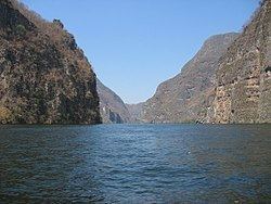
Nezahualcoyotl lake on grijalva river chiapas mexico
Grijalva River, formerly known as Tabasco River. (Spanish: Río Grijalva, known locally also as Río Chiapa and Mezcalapa River) is a 480 km long river in southeastern Mexico. It is named after Juan de Grijalva who visited the area in 1518. The river rises in Chiapas highlands and flows from Chiapas to the state of Tabasco through the Sumidero Canyon into the Bay of Campeche. The river's drainage basin is 134,400 km² in size.
Contents
- Nezahualcoyotl lake on grijalva river chiapas mexico
- Map of Grijalva River Tabasco Mexico
- 2 hour tour on grijalva river through canyon
- References
Map of Grijalva River, Tabasco, Mexico
After flowing from Nezahualcoyotl Lake, an artificial lake created by the hydroelectric Malpaso Dam, Grijalva River turns northward and eastward, roughly paralleling the Chiapas-Tabasco state border. It flows through Villahermosa (where, in 2001, a new cable-stayed bridge was constructed to cross the river) and empties into the Gulf of Mexico, approximately 10 km northwest of Frontera. The river is navigable by shallow-draft boats for approximately 100 km upstream.