
Owned by WMATA Connections Fairfax Connector: 422 Disabled access Yes Connection Fairfax Connector Tracks 2 | Structure type Open-cut Opened 26 July 2014 Platforms in use 1 | |
 | ||
Location 8304 Leesburg Pike (South Entrance)8305 Leesburg Pike (North Entrance)Tysons Corner, Virginia 22102 Address Leesburg Pike, McLean, VA 22102, USA Owner Washington Metropolitan Area Transit Authority Similar Spring Hill station, Tysons Corner station, Wiehle–Reston East station, McLean station, West Falls Church station | ||
Greensboro (preliminary names Tysons Central 7, Tysons Central) is a Washington Metro station in Tysons Corner, in Fairfax County, Virginia, on the Silver Line. It opened on July 26, 2014 as part of phase 1 of the Silver Line. Greensboro is one of four Metro stations in the Tysons Corner area and is to be part of the massive regeneration of the district.
Contents
Station layout
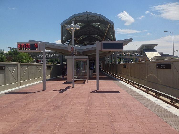
Like Spring Hill station, Greensboro was built in the median of SR 7 with a single island platform serving two tracks. However, unique amongst all Silver Line stations in Tysons Corner, it was built partially at ground level and sub-surface. The construction and overall design of the station have been likened to that of Naylor Road on the Green Line because of its depressed but open-air layout. This is the result of the south end of the station acting as the western portal for the connecting tunnel leading to SR 123 while SR 7 slopes upwards towards the east. A mezzanine covering the central half of the platform will contain ticket machines and faregates; two aerial walkway exits will cross either side of Route 7 and meet at the mezzanine. The main platform has a height of −12 feet (−3.7 m) at its east end and 12 feet (3.7 m) at its west end.
History
Greensboro station opened as part of the first phase of the Silver Line to Wiehle – Reston East in 2014. In the planning stages, controversy ensued over whether to build the Metro in a tunnel or on an elevated viaduct through Tysons Corner. It was eventually decided that the majority of the line would be built above ground, but the station will be built partially below ground in order to send trains through a short tunnel connecting the line's Route 7 and Route 123-paralleling sections.
Location
Greensboro station is located within west-central Tysons Corner, specifically in the median of Route 7 (Leesburg Pike). Much of the surrounding area is commercial in nature, with the Pike Seven Plaza Shopping Center to the west and Tysons Galleria to the east with little in the way of residential development. Traffic counts by the Virginia Department of Transportation (VDOT) show that the section of Leesburg Pike on which the station will sit is the most heavily used in Fairfax County, with 61,000 vehicles per day using the stretch of road between Route 123 and the Dulles Toll Road.
Transit-oriented development
In order to reduce congestion and improve walkability and connectivity in the area, the Fairfax County Planning Commission created the "Tysons Corner Urban Center Comprehensive Plan", an outline for the urbanization of Tysons Corner in conjunction with the opening of the Silver Line. As one of four Metro stations within the identified locale, Greensboro is the focal point of one of the transit-oriented development schemes in the plan. According to the Commission's outline, the area bounded by Route 123, Gosnell Drive, Westpark Drive, and International Drive will be designated as the Tysons Central 7 District and contain high-density residential and commercial mixed-use development.
The Tysons Central 7 District is divided into two sub-districts, North and South, separated by Route 7. The south sub-district is approximately 76 acres (31 ha) large and will contain mixed-use development, with offices predominating near the station and residential buildings in the outer transition zone. The plan calls for a "civic commons" to be the central open space in the sub-district with government and civi-related buildings surrounding it. The north sub-district is similar in nature, but is 102 acres (41 ha) in area. In contrast, the north sub-district is planned to be more vibrant and 24-hour than the south, with a minimum building height of 175 feet (53 m), although both sectors have a maximum allowance of 400 feet (122 m). To connect these districts, it is envisioned that Leesburg Pike will be reconfigured, along with Chain Bridge Road, to a "boulevard" design, with a median separating four lanes of traffic each way, as well as landscaping the sidewalks to improve walkability. Radiating out from Route 7 will be a series of avenues and collector streets, each with different regulations to create a hierarchical street grid.