
 | ||
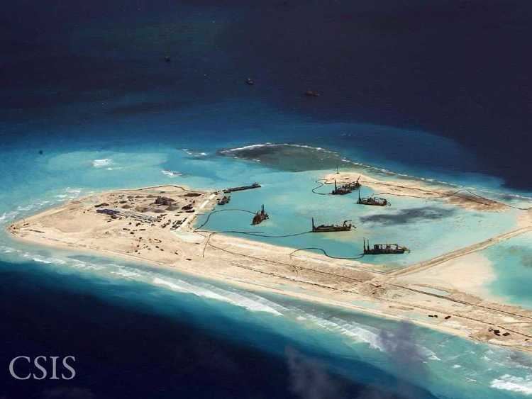
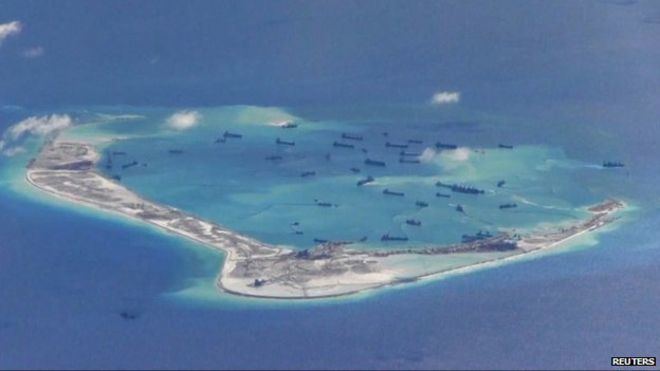
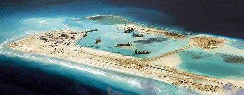
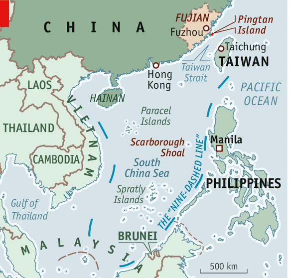
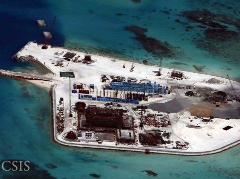
The "great wall of sand" is a name used by the media for a series of land reclamation projects undertaken by the PRC since late 2013 in the South China Sea – particularly in the Spratly islands group – in order to strengthen PRC territorial claims to the region demarcated by the "nine-dash line". They are created by dredging sand onto coral reefs to create artificial islands which are then concreted to make permanent structures. By the time of the 2015 Shangri-La Dialogue, over 810 hectares (2,000 acres) of new land had been created. By June 2015, the land reclamation had reached 3,200 acres (1,300 ha) (13km2) (5 square miles) and by December 2016 "'significant' weapons systems, including anti-aircraft and anti-missile systems" had been installed.
Contents
- Reclamation activities
- Machinery
- Strategic importance
- Legal issues
- Territorial waters of an artificial island
- Environmental legal issues
- Regional concept
- States
- Organizations
- Ecological impact
- References
China states that the construction is for "improving the working and living conditions of people stationed on these islands" and that, "China is aiming to provide shelter, aid in navigation, weather forecasts and fishery assistance to ships of various countries passing through the sea." Defence analysts IHS Janes states that it is a "methodical, well planned campaign to create a chain of air and sea-capable fortresses". These "military-ready" installations include sea-walls and deep-water ports, barracks, and notably including runways on Fiery Cross Reef and Johnson South Reef. Aside from geo-political tensions, concerns have been raised about the environmental impact on fragile reef ecosystems through the destruction of habitat, pollution and interruption of migration routes.
There is no known official term for the projects; the phrase "great wall of sand" was first used by Harry Harris, commander of the US Pacific Fleet, in March 2015.
Other countries in the region are also undertaking, on a far smaller scale, similar operations. The U.S. Pentagon's estimates in 2015 for the amount of reclaimed land was: China (2,900 acres), Vietnam (80 acres), Malaysia (70 acres), the Philippines (14 acres) and Taiwan (8 acres).
Reclamation activities
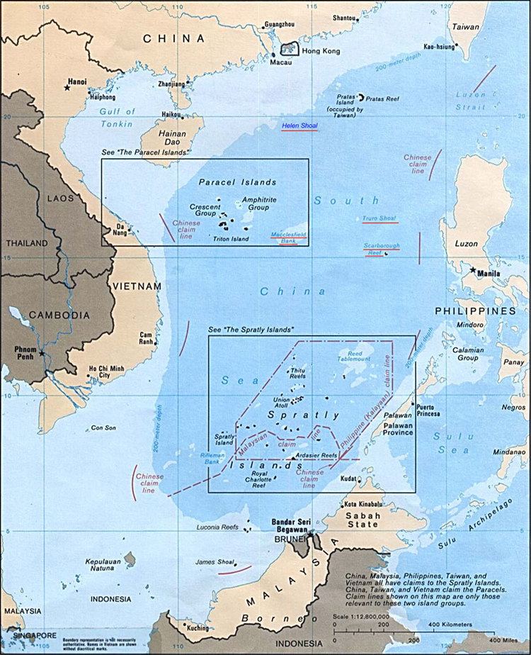
The Asia Maritime Transparency Initiative's "Island tracker" lists the following locations as sites of island reclamation activities:
^ The official Chinese names still use Jiāo (礁) meaning "reef", as previously in e.g. the Chinese: 赤瓜礁海战; pinyin: Chìguā jiāo hǎizhàn, the "Johnson South reef naval battle". Unofficially, the term Dǎo (岛) meaning "island" is gaining popularity. So the place of that naval battle may be called as Chinese: 赤瓜岛; pinyin: Chìguā Dǎo casually.
Total reclaimed area on these 7 reefs: 13.5 km2 (3,300 acres)
Machinery
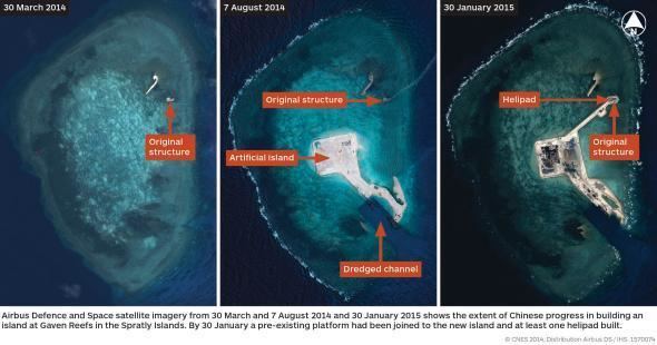
China used hundreds of dredges and barges including a giant self-propelled dredger, the Tian Jing Hao. Built in 2009 in China, the vessel, Tian Jing Hao, is a 127 m-long seagoing cutter suction dredger designed by German engineering company Vosta LMG; (Lübecker Maschinenbau Gesellschaft (de)). At 6,017 gross tonnes, with a dredging capacity of 4500m3/h, it is credited as being the largest of its type in Asia. It has been operating on Cuarteron Reef, the Gaven Reefs, and at Fiery Cross Reef.
Strategic importance
More than half of the world's annual merchant fleet tonnage passes through the Strait of Malacca, Sunda Strait, and Lombok Strait, with the majority continuing on into the South China Sea. Tanker traffic through the Strait of Malacca leading into the South China Sea is more than three times greater than Suez Canal traffic, and well over five times more than the Panama Canal. The People's Republic of China (PRC) has stated its unilateral claim to almost the entire body of water.
Legal issues
Unilateral declared sovereignty.
Territorial waters of an artificial island
Artificial islands built on a submerged feature
As the Mischief and Subi Reefs were under water prior to reclamations, they are considered by the Third United Nations Conference on the Law of the Sea (UNCLOS III) as "sea bed" in "international waters". Although the PRC had ratified a limited UNCLOS III not allowing innocent passage of war ships, according the UNCLOS III, features built on the sea bed cannot have territorial waters.Artificial islands built on a rock
Artificial islands built in disputed waters
Environmental legal issues
The PRC has ratified UNCLOS III; the convention establishes general obligations for safeguarding the marine environment and protecting freedom of scientific research on the high seas, and also creates an innovative legal regime for controlling mineral resource exploitation in deep seabed areas beyond national jurisdiction, through an International Seabed Authority and the Common heritage of mankind principle.
Regional concept
According to Chinese sources, the concept was invented in 1972 by the Bureau of Survey and Cartography of Vietnam under the Office of Premier Phạm Văn Đồng which printed out "The World Atlas" and said "The chain of islands from the Nansha and Xisha Islands to Hainan Island, Taiwan Island, the Penghu Islands and the Zhoushan Islands are shaped like a bow and constitute a Great Wall defending the China mainland."
States
Organizations
Ecological impact
Aside from geo-political tensions, concerns have been raised about the environmental impact on fragile reef ecosystems through the destruction of habitat, pollution and interruption of migration routes. These new islands are built on reefs previously 1m below the level of the sea. For back-filling these 7 artificial islands, a total area of 13.5 million m2, to the height of few meters, China had to destroy surrounding reefs and pump 40 or 50 million m3 of sand and corals, resulting in significant and irreversible damage to the environment. Frank Muller-Karger, professor of biological oceanography at the University of South Florida, said sediment “can wash back into the sea, forming plumes that can smother marine life and could be laced with heavy metals, oil and other chemicals from the ships and shore facilities being built.” Such plumes threaten the biologically diverse reefs throughout the Spratlys, which Dr. Muller-Karger said may have trouble surviving in sediment-laden water.
Rupert Wingfield-Hayes, visiting the vicinity of the Philippine-controlled island of Pagasa by plane and boat, said he saw Chinese fishermen poaching and destroying the reefs on a massive scale. As he saw Chinese fishermen poaching endangered species like massive giant clams, he noted “None of this proves China is protecting the poachers. But nor does Beijing appear to be doing anything to stop them. The poachers we saw showed absolutely no sign of fear when they saw our cameras filming them”. He concludes: “However shocking the reef plundering I witnessed, it is as nothing compared to the environmental destruction wrought by China's massive island building programme nearby. The latest island China has just completed at Mischief Reef is more than 9km (six miles) long. That is 9km of living reef that is now buried under millions of tonnes of sand and gravel.”
A famous 2014 United Nations Environment Programme (UNEP) report said: "Sand is rarer than one thinks".
The average price of sand imported by Singapore was US $3 per tonne from 1995 to 2001, but the price increased to US $190 per tonne from 2003 to 2005. Although the Philippines and the PRC had both ratified the UNCLOS III in the case of Johnson South Reef, Hughes Reef and Mischief Reef, the PRC dredged sand for free in the EEZ the Philippines had claimed from 1978, arguing this to be the "waters of China's Nansha Islands."
Although the consequences of substrate mining are hidden, they are tremendous. Aggregate particles that are too fine to be used are rejected by dredging boats, releasing vast dust plumes and changing water turbidity.
John McManus, a professor of marine biology and ecology at the University of Miami’s Rosenstiel School of Marine and Atmospheric Science, said: “The worst thing anyone can do to a coral reef is to bury it under tons of sand and gravel.” “There are global security concerns associated with the damage. It is likely broad enough to reduce fish stocks in the world’s most fish-dependent region,” He explained that “[the reason] the world has heard little about the damage inflicted by the People's Republic of China to the reefs is that the experts can’t get to them.” and noted “I have colleagues from the Philippines, Taiwan, PRC, Vietnam and Malaysia who have worked in the Spratly area. Most would not be able to get near the artificial islands except possibly some from PRC, and those would not be able to release their findings.”