
Length 100 km (62 mi) NE/SW | Elevation 1,444 m Type of rock Diabase | |
 | ||
Similar | ||
Highway 1 australia s greatest road trip great western tiers
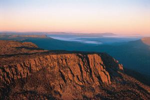
The Great Western Tiers are a collection of mountain bluffs that form the northern edge of the Central Highlands plateau in Tasmania, Australia. The bluffs are contained within the Tasmanian Wilderness World Heritage Site.
Contents
- Highway 1 australia s greatest road trip great western tiers
- Map of Great Western Mountains Central Plateau TAS 7304 Australia
- Pine lake great western tiers
- Features
- Peaks
- References
Map of Great Western Mountains, Central Plateau TAS 7304, Australia
The bluffs stretch northwest to southeast over 100 kilometres (62 mi) from the 1,420-metre (4,660 ft) Western Bluff near the town of Mole Creek to the 1,210-metre (3,970 ft) Millers Bluff, approximately 25 kilometres (16 mi) west of Campbell Town.
Pine lake great western tiers
Features
The tiers form an escarpment between the high, rocky, sparsely inhabited central plateau and the lower land of the Meander Valley and the northern midlands. The edge of the tiers have prominent cliffs and columns of Jurassic dolerite. The highest peak in the tiers is the 1,443-metre (4,734 ft) Ironstone Mountain. Unlike most of the bluffs this mountain is not visible from the Meander Valley, but is south of the escarpment. The dolerite is so prominent as the older rocks that overlay them are softer and have been eroded away. In places dolerite columns have collapsed into scree slopes. Many walking tracks ascend the face of the Tiers.
Peaks
The peaks and bluffs of the Great Western Tiers include: