
- left Xolobe Length 520 km Mouth elevation 0 | ||
 | ||
Sources Wit-Kei River, Black Kei River | ||
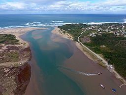
The Great Kei River (Afrikaans: Groot-Keirivier) is a river in the Eastern Cape province of South Africa. It is formed by the confluence of the Black Kei River (Afrikaans: Swart-Keirivier) and White Kei River (Afrikaans: Wit-Keirivier), northeast of Cathcart. It flows for 320 km (199 mi) and ends in the Great Kei Estuary at the Indian Ocean with the small town Kei Mouth on the west bank. Historically the Great Kei River formed the southwestern border of the Transkei region.
Contents
Map of Groot-keirivier, South Africa
Dams in the Great Kei basin
References
Great Kei River Wikipedia(Text) CC BY-SA