
Country United States FIPS code 45-30490 Elevation 149 m Population 1,956 (2013) Area code 803 | Time zone Eastern (EST) (UTC-5) GNIS feature ID 1222851 Zip code 29055 Local time Thursday 4:35 AM | |
 | ||
Weather 2°C, Wind S at 2 km/h, 83% Humidity Area 11.4 km² (10.88 km² Land / 26 ha Water) | ||
How to say or pronounce usa cities great falls south carolina
Great Falls is a town in Chester County, South Carolina, United States and is located fourteen miles southwest of Lancaster, South Carolina. The population was 1,979 at the 2010 census.
Contents
- How to say or pronounce usa cities great falls south carolina
- Map of Great Falls SC 29055 USA
- Geography and climate
- History and culture
- Notable residents
- Demographics
- References
Map of Great Falls, SC 29055, USA
Geography and climate
Great Falls is located at 34°34′15″N 80°54′1″W (34.570912, -80.900238).
According to the United States Census Bureau, the town has a total area of 4.4 square miles (11 km2), of which, 4.2 square miles (11 km2) of it is land and 0.1 square miles (0.26 km2) of it (3.19%) is water.
History and culture
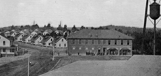
Great Falls was first known as Catawba Falls, which was named for the waterfall there on the Catawba River. The first Republic textile/cotton mill was built in 1909, after a hydroelectric plant was built, providing electricity to the town. The roots of Duke Energy, one of the largest power companies in the U.S., are in Great Falls. The company which would evolve into Duke Energy, Southern Power Company, was chartered in 1905, when tobacco baron James B. Duke and Dr. W. Gill Wylie, a Chester native and New York physician, implemented a plan to harness energy from the roaring Catawba River here. The "company store" near the mill provided the workers with everything that they could possibly need, and deducted payments on these goods from the workers' wages. By 1923, two more Republic mills were in operation in Great Falls, which caused the "mill villages" to be referred to as #1, #2 & #3, depending on which mill the houses were closest to. The Duke Foundation was the principal stockholder until 1946 when the mills were sold to J.P. Stevens and Co. The mills remained in operation until 1980.
Up the road, or 'down,' depending on your perspective, a merchant named Andy Morrison, who had a drooping eyelid, would sell many of the same items at lower prices. The company tried to discourage its workers from trading with 'that old flopeyed man' down the road. However, people liked his prices, and seemed to genuinely like old 'Flopeye.' This caused the area around the #1 mill, company store, bank, and First Baptist Church to be referred to as "Downtown", while the other retail area, where "Flopeye" ran his place of business, came to be called "Flopeye". To this day, there are two separate and distinct business areas in Great Falls. The main street, Dearborn, which connects these two areas, winds past Republic Park, a football stadium-come-baseball field that is home of the 1934 State Champions with noted player Banks McFadden, several churches, the elementary school, and the single remaining grocery store.
The Flopeye Fish Festival is held on the Saturday of Memorial Day weekend at 2534 James Baker Blvd, off Highway 21 north of Great Falls at the Industrial park. Admission is FREE. The Flopeye Fish Festival brings about a community-wide recreational highlight. With a variety of food, fun and entertainment accompanied by the enthusiasm of a homecoming atmosphere, the festival attracts visitors from many states. The event brings our citizens together and preserves the history of the area known as Flopeye.
The Great Falls Depot, Great Falls Downtown Historic District, and Republic Theater are listed on the National Register of Historic Places.
Notable residents
Demographics
As of the census of 2000, there were 2,194 people, 892 households, and 595 families residing in the town. The population density was 516.8 people per square mile (199.3/km²). There were 1,041 housing units at an average density of 245.2 per square mile (94.6/km²). The racial makeup of the town was 71.01% White, 27.94% African American, 0.27% Native American, 0.23% Asian, 0.36% from other races, and 0.18% from two or more races. Hispanic or Latino of any race were 0.73% of the population.
There were 892 households out of which 33.1% had children under the age of 18 living with them, 41.1% were married couples living together, 20.2% had a female householder with no husband present, and 33.2% were non-families. 30.9% of all households were made up of individuals and 17.2% had someone living alone who was 65 years of age or older. The average household size was 2.46 and the average family size was 3.05.
In the town, the population was spread out with 28.0% under the age of 18, 8.6% from 18 to 24, 25.9% from 25 to 44, 20.4% from 45 to 64, and 17.2% who were 65 years of age or older. The median age was 35 years. For every 100 females there were 89.1 males. For every 100 females age 18 and over, there were 82.2 males.
The median income for a household in the town was $24,758, and the median income for a family was $31,683. Males had a median income of $27,336 versus $22,070 for females. The per capita income for the town was $13,266. About 16.4% of families and 18.1% of the population were below the poverty line, including 23.9% of those under age 18 and 20.4% of those age 65 or over.