
Coat of arms Flag Cities/towns 1 Area 853.8 km² | Rural localities 39 Founded 1928 | |
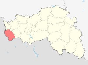 | ||
Grayvoronsky District (Russian: Грайворонский райо́н) is an administrative district (raion), one of the twenty-one in Belgorod Oblast, Russia. Municipally, it is incorporated as Grayvoronsky Municipal District. It is located in the west of the oblast. The area of the district is 853.8 square kilometers (329.7 sq mi). Its administrative center is the town of Grayvoron. Population: 29,137 (2010 Census); 31,567 (2002 Census). The population of Grayvoron accounts for 21.4% of the district's total population.
Contents
Map of Grayvoronsky District, Belgorod Oblast, Russia
Geography
Grayvoronsky District sits at the southwest corner of Belgorod Oblast, on the border with Ukraine. It is bordered on the south and west by Kharkiv Oblast and Sumy Oblast (both of Ukraine), on the north by Krasnogvardeysky District, Belgorod Oblast and Rakityansky District, and on the east by Borisovsky District. The administrative center of the district is the town of Grayvoron. The district is 50 km west of the city of Belgorod, and is 55 km northwest of the Ukrainian city of Kharkiv.
The terrain is hilly plain averaging 200 meters above sea level; the district lies on the Orel-Kursk plateau of the Central Russian Upland. The major river through the district is the Vorskla River, which flows east to west through the district, eventually to join the Dnieper River.