
Population 2,796 (2011 census) | Postcode(s) 2232 Postal code 2232 | |
 | ||
Location 29 km (18 mi) S of Sydney CBD | ||
Grays Point is a suburb in southern Sydney, in the state of New South Wales, Australia 29 kilometres south of the Sydney central business district, in the local government area of the Sutherland Shire.
Contents
Map of Grays Point NSW 2232, Australia
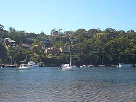
Grays Point is a small suburb with picturesque views of the Port Hacking estuary. Grays Point is adjacent to the Royal National Park and the suburbs of Gymea Bay and Kirrawee. There is only one road available for vehicular access however multiple walking and mountain bike tracks link it with locations such as Audley in the Royal National Park, Engadine and Heathcote.
There is a small shallow boat ramp located at Swallow Rock Reserve for launching trailer boats, canoes and kayaks. Swallow Rock is a wetland area. A large variety of wildlife resides in Grays Point, including possums, sugar gliders, morepork owls, deer (an introduced species), wallabies, magpies and kookaburras.
History
The origin of the Grays Point name is unclear. It has been suggested that it was either named after Samuel William Gray, who owned land on the point or John Edward Gray, who was a well-known resident ranger in the Royal National Park in the 1880s.
Population
At the 2011 census, there were 2,796 residents in Grays Point. The majority of people were born in Australia and the most common ancestries were English, Australian and Irish. The top responses for religious affiliation were Anglican 28.8%, Catholic 26.7% and No Religion 21.9%. The median household weekly income of $2,285 was substantially higher than the national median of $1,234. The majority of occupied dwellings were separate houses and these tended to be large properties, with 56.2% having 4 or more bedrooms.
Commercial area
Grays Point is largely residential, with a small group of shops located at Grays Point Road, near the intersection of Swallow Rock Drive. A fish and chip shop, a hairdresser, a restaurant, a bottle shop, a convenience store that used to act as the post office. Most residents rely on the rest of the Sutherland Shire for their services.
Schools
Grays Point Public School is located in Angle Road. The school lies next to the Grays Point ovals and is cut out of the Royal National Park. The school serves local children from kindergarten to year 6 with around 400 students. It focuses on positive student well being programs and advancing technology skills. Grays Point also has a preschool and a child care centre.
Sport
Grays Point Soccer Club located next to the Public School, the club has Junior and Senior teams. The club has two playing fields.