
Location Alger County, Michigan Basin countries United States Max. width 0.7 mi (1.1 km) Area 255 ha Length 3.5 km | Primary outflows Sable Creek Max. length 2.2 mi (3.5 km) Surface elevation 226 m Mean depth 12 m Width 1.1 km | |
 | ||
Primary inflows | ||
Two alaskan malamutes walking along the shore of grand sable lake
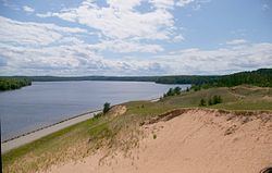
Grand Sable Lake is an undeveloped lake in Michigan's Upper Peninsula near the town of Grand Marais, Michigan. It lies within the boundaries of the Pictured Rocks National Lakeshore.
Contents
- Two alaskan malamutes walking along the shore of grand sable lake
- Map of Grand Sable Lake Pentland Township MI 49868 USA
- Tour of grand sable lake near grand marais michigan may 2010
- References
Map of Grand Sable Lake, Pentland Township, MI 49868, USA
County Highway H-58 runs along the northwestern shore of the lake and provides access to the Grand Sable Dunes which overlook the lake. Additionally, there is a sandy beach and picnic area available to visitors. There is a concrete boat access site on the eastern shore of the lake.
The soils around Grand Sable Lake are very sandy and the shoreline is mostly wooded
Tour of grand sable lake near grand marais michigan may 2010
References
Grand Sable Lake Wikipedia(Text) CC BY-SA