
Area 14 km² Population 18,000 (2010) | Postal code IS-112 Urban area 7.7 km² Municipality Reykjavik | |
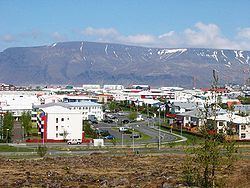 | ||
Grafarvogur ([ˈkraːvarˌvɔːɣʏr̥]) is among the largest residential districts of Reykjavík, Iceland. It is a relatively new neighbourhood, major construction began in the late 1980s and continued well into the 1990s.
Contents
Map of Grafarvogur, Reykjav%C3%ADk, Iceland
Neighbourhoods
The district includes 14 neighbourhoods: Hamrar, Foldir, Hús, Rimar, Borgir, Víkur, Engi, Spöng, Staðir, Höfðar, Bryggjuhverfi, Geirsnef, Gufunes, Geldinganes. Of those, five (Rimar, Hamrar, Borgir, Víkur and Foldir) fall within the boundaries of historic Gufunes estate.
Shopping
Grafarvogur currently has one medium-sized shopping centre called Spöngin. It's not a mall in itself but a cluster of stores, Hagkaup being the largest. Also there are small clusters of stores in Hverafold, by Víkurvegur and Langirimi Streets. Those are much smaller and contain only a few stores, the supermarkets being the largest of the few.